
They’re strong on “thongs” in Summer Wine country. Before you blanch at the thought of Nora Batty in one, I hasten to add that these “thongs” are in place names: Upperthong, Netherthong, Thongbridge.
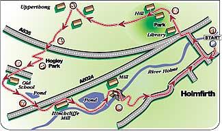
It was Upperthong that was the first port of call on this walk, which started in the heart of Holmfirth on a sunny (if hazy) Sunday morning.
There were few people around when we parked up in the one-time mill village which has been given a new lease of life by the television series filmed in and around it for the last quarter of a century. It’s also famous as the home of Bamforth’s saucy postcards, produced by the family who long ago were pioneers in the making of silent movies.
Everywhere you walk around here are reminders of Clegg, the late, much-lamented Compo, the various characters who have made up the third pensioner of the wayward trio over the years and their assorted eccentric friends and neighbours
Take Victoria Park, for instance, which we climbed up through on our way out of Holmfirth. I half expected to come across Howard and Marina peeping out from behind a bush, pretending to be bird-spotting, or to find Foggy pouring out his interminable jungle-warfare memoirs to some poor bloke who’d had the misfortune to sit next to him on a bench.
From the top of the park we headed through a cluster of attractive houses (this walk passes a lot of them) before climbing up steep and sometimes sloping steps to the aptly-named hamlet of Hill, which is at the top of one.
From there we were quickly out into open countryside, wandering along a butterfly-busy walled lane between meadows of wild flowers and wishing that the open views in all directions weren’t quite so shrouded in mist.
Before long we were in Upperthong. And a lovely little place it is too: pretty cottages everywhere you look, and a pub at the top of Towngate which, had it been open, would have provided a pleasant port of call on such a warm day.
However, it was still early and the open road beckoned again. We left the village and soon were on a rough lane between fields and passing a solid row of 18th century cottages before descending steeply down the narrow road into the leafy shade of Hart Holes Clough and climbing just as steeply up the other side again to the hamlet of Hogley.
From here we headed through the fields for a while, at one stage feeling a little disconcerted to find a horse standing right beside the stile that we needed to exit from the field. However, we proceeded with caution and it totally ignored us until the stile gate swung shut behind us. Then it reared, whinnied and galloped off. It had been asleep, and rudely awakened.
We emerged back into the road (Cold Well Lane) via an ancient stile and a slab bridge over a trickling stream, just across the road from a schoolhouse dated 1816 and now converted into an enviable house. Our track led round the back of this and down to follow another leafy clough on a path running greenly above it to eventually descend to the A6024 Woodhead Road at Hinchcliffe Mill.
Soon we were walking upstream alongside the peaceful River Holme, down which the waters roared when the dam of Bilberry Reservoir burst after a torrential downpour in 1852, claiming 81 lives. We emerged on the banks of a calm mill pond (see picture, top of page) where anglers sat staring at their immobile floats before crossing a footbridge over the Holme and doubling back on ourselves for a while to climb up a steep meadow into woodland, passing a quarry on our way to join the fields path leading to a road, Brow Lane.
From here, our way back to Holmfirth was clear and easy, past fields in which sheep and lambs were sheltering from the warming sun in the shade of ancient walls.
When we arrived back in the town it was packed with tourists - and with Morris Dancers, who seemed to be performing on every corner. As one group put themselves through their hanky-waving paces outside Ivy’s Café, I half expected to see the ghost of Compo giggling to himself in the shadows before joining the dancers in a vain attempt to impress his beloved Nora.
Step by Step
- From centre of Holmfirth, walk up Victoria Street to main road and cross. Turn left to pass Tourist Information Centre then go right, walking up past library car park into Victoria Park. Take path that curves up to right, following it to top of park then emerging via a snicket into the road (Cooper Lane). Walk up to T-junction.
- Dogleg right briefly, then follow footpath sign left up between gardens via steep steps to reach Hill. Continue up driveway between houses, turning left at top on to road that soon become a walled track leading between fields to Upperthong.
- Where track meets road, go ahead up Towngate to pass Royal Oak pub. At T-junction, go left down Wickens Lane, leaving village. Go right soon, following footpath sign right along walled track to pass row of cottage on right and come to Greenfield Road (A635).
- Cross and walk down road ahead (Black Sike Lane), climbing steeply up other side to houses of Hogley Green. Swing right with road briefly, then take first left along driveway which soon forks. Take left fork, passing between houses to arrive at cluster of houses (Hogley), veering right to stile beside gate into field.
- Walk ahead, with wall on left, to stile into next field and continue in same line to next stile. From here, walk across middle of field to another stile and then follow wall down to stile and stone-slab bridge over stream into Cold Well Lane.
- Go right briefly, to follow path left behind converted schoolhouse which arrives at stile into open area bound by walls. Go through stile then veer left (ignoring gates and stile ahead) to follow clear track which soon becomes grassy path above wooded clough with a millpond at end of it. Where path ends at stile into access road to houses of Upper Stubbin, go right as requested by sign, quickly turning left into a field with a descending causeway to stile to left of facing gate at bottom. Through this, follow Stubbin Lane down to A6024.
- Cross over, then go left along Old Road, passing cottages then forking right on Water Street to pass Hinchcliffe Mill on right. Ignore metal footbridge and continue ahead on left-hand bank of River Holme, with mill race on left, until you come to mill pond. Continue around this, veering right away from it to footbridge and crossing river.
- Go RIGHT here, backtracking and soon taking left-hand rising fork to follow path as it swing round hillside to meet a crossing path. Go left up this, to arrive at wall stile into wood. Turn left, then quickly take right-hand fork up through wood, passing through narrow gap just before quarry. At another, level, crossing path go ahead, climbing to left of quarry to stile into field. Cross this, and then another, heading for cluster of houses. Go through stile by gate and through garden into drive, and walk up access road to road. Turn left to walk back to Holmfirth.
Fact File
- Time for 4½-mile walk: two hours.
- Going: easy except for a couple of steep pulls.
- Map:OS Explorer 288, Bradford & Huddersfield.
- Getting there: by car via Huddersfield, following Holmfirth signs off ringroad. Or by bus from Huddersfield.
- Toilets: in Holmfirth.
- Refreshments: lots in Holmfirth, plus pub at Upperthong.


Comments: Our rules
We want our comments to be a lively and valuable part of our community - a place where readers can debate and engage with the most important local issues. The ability to comment on our stories is a privilege, not a right, however, and that privilege may be withdrawn if it is abused or misused.
Please report any comments that break our rules.
Read the rules hereComments are closed on this article