
It had been a nerve-wracking drive up lovely Coverdale, following the undulating, winding road from Kettlewell towards Leyburn and dodging tiny rabbits along much of the way.
I've never seen so many baby bunnies strung out along the verges, nibbling the grass and apparently unconcerned by the passing traffic, or sitting in the middle of the road looking gormless and declining to shift until they were hooted at.
Many of them were slow off the mark and there was plenty of sad evidence along the road of the ones which had lost out in the battle between motor vehicle and animal kingdom.
As far as I know, we didn't damage a single one of these creatures as we travelled the roller-coaster miles of this dale. I never took my eyes off the road, and was constantly swerving and braking. Their survival was at the expense of my being able to glance around at the splendid scenery, but I suppose it was a small price to pay.
I did look up, though, as we made the descent of the Witton Steeps between Melmerby and West Witton, to see the dark eastern shoulder of Penhill topped with its beacon and in need of a bit of sunshine to cheer it up.
That was to be our destination for this walk. From this point, it looked like a gentle ascent. Easy-peasy. By the time we'd reached West Witton itself, though, down in the valley bottom, it seemed like more of a challenge - even though, at 1,684 feet, Penhill Beacon is hardly on what you might call a mountain.
First challenge, though, was finding somewhere to park in this linear village strung along the A684 main road through Wensleydale. We ended up in the long lay-by out of the eastern end of the village, and headed from there back to the Wensleydale Heifer pub to start the walk proper.
"It's looking a bit stormy," said a local man as we passed him at the entrance to the zig-zag snicket which led us behind houses and into the fields. "Could be raining heavy by dinner time."
We told him that we planned to be back by then, which seemed to disappoint him, then made our own study of the sky when we were out of sight of him. There was plenty of blue, and lots of white cumulous clouds with just the odd clump of unthreatening grey.
A bit of gentle climbing followed by level pegging along a grassy lane took us to the road we'd just driven down at the foot of the Witton Steeps. A spot of uphill road walking, then a fields path to cut off a long corner, then the road again - and before too long we were turning to walk across the rising fields towards that Penhill Beacon.
Mindful of the fact that only two days earlier an elderly walker had been badly injured by cattle, we gave the herd of grazing cows in the first field a wide, respectful berth and were glad when the gate swung shut between them and us. Our anxiety was probably quite unnecessary. He had been walking with a dog, and the cattle had calves. We had no dog and these were all calfless cows.
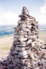
As we approached the final gate leading to the last, steep push up Penhill, the sun came out and illuminated the beacon and the grassy slopes leading up to it. It was a warm welcome as we slogged up the well-trodden slope, stopping from time to time to catch our breath and admire the view.
And what a view it is from up here: mile after mile of Yorkshire stretching away to the east, across the plain to the Hambleton hills. And directly across Wensleydale, the fine landmark of Castle Bolton, its warm stone glowing in the sunshine.
We turned to head up the dale, walking along the ridge above the high crags from which the Penhill Giant is reputed to have plunged to his doom, before turning to scramble down towards the valley bottom via fields paths and good tracks.
A few spots of rain fell as we strode out along the last half-mile back to West Witton, but then it stopped. It seemed that the local man's forecast might be wrong.
Oh no it wasn't! As we drove towards home, heading through Leyburn towards Middleham, the heavens opened and torrential rain bounced a foot up from the road around us. If that lot had caught us out on the top of Penhill, the views would have quickly been forgotten.
Step by Step
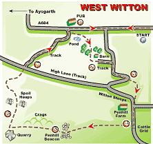
- From Wensleydale Heifer Inn, in middle of West Witton, cross road and follow footpath sign ahead, turning left just before pond to follow signpost up zig-zag snicket behind houses and emerge into field. Go half left across field to a stile then on towards another across next field. Turn right before going over this stile, and walk up fieldside to stile into wood. Follow path half-right to climb up through wood. Take left-hand of two stiles at top, and go ahead to follow tree line to meet a crossing green lane.
- Turn left and walk along lane to pass barn on left. Where lane meets a gate, go through stile on right of it and continue through fields parallel to lane (which can be very wet) to emerge eventually into road. Turn right and walk up road to where it turns sharp right.
- Go through stile in wall on this bend and walk ahead up field, keeping to path which runs parallel to wall on left until the two meet near the top. Emerge into the road again opposite Penhill Farm. Walk up road past farm to gate on right just before cattle grid, with signpost.
- Go through gate and walk directly ahead, up hill, heading for gate in far wall of field. From here path is clear ahead, through several gates and ending in full-frontal assault of Penhill to Beacon.
- From Beacon, head west up dale taking right-hand path close to ridge. Go over stile at end of wall and keep ahead to eventually go through gap in fence. Continue with wall to left to a large gate-gap in wall with quarry beyond. Turn sharp right here to go down clear, semi-paved path and follow it as, lower down, it zigzags down to grass-covered spoil heap.
- Go round to back of spoil heap and follow broken-down wall straight down field to meet crossing path (just past water trough). Turn left on this until it veers right to gate in wall. Through this, go half left toward wall then follow path round right to signpost and down a dip to then veer right towards gate below into next field. Take left-most path down this field to another gate into High Lane, opposite start of another walled lane.
- Walk up this facing lane to pass barn and quarry and, eventually, caravan site and return to West Witton.
Fact File
- Time for 6-mile walk: three hours.
- Going: easy enough apart from a couple of strenuous ascents.
- Map: OS Outdoor Leisure 30, Yorkshire Dales Northern & Central.
- Refreshments: in West Witton with more in nearby Leyburn.
- Toilets: none on route.
- Getting there by car: drive up Wharfedale to Kettlewell then take the restricted road towards Leyburn via Coverdale, taking left turn towards West Witton. Return, if you like, via Leyburn, Middleham, Ripon and Harrogate.
- By public transport: by train via Leeds to Northallerton then Dales & District bus service 157 to West Witton.


Comments: Our rules
We want our comments to be a lively and valuable part of our community - a place where readers can debate and engage with the most important local issues. The ability to comment on our stories is a privilege, not a right, however, and that privilege may be withdrawn if it is abused or misused.
Please report any comments that break our rules.
Read the rules hereComments are closed on this article