
IN the mid-1980s, nearly 40 years ago now, I tutored a local history class at the Cathedral Centre, Captain Street.
As part of our studies, we carried out research into the surrounding Wapping district. I also interviewed a number of former residents. This then formed a small exhibition at Bradford Central Library, which aroused much interest. This article is some snapshots from this research into one of the many old Bradford neighbourhoods, which have now almost completely vanished.
The area was developed following the construction of a new road, Bolton Road, at the beginning of the 1820s. Wapping Road was a branch of this and, together with North Wing, they formed the boundaries of the district. From the first, it was a poor area. A report prepared in 1848 by the Bradford Woolcombers documented the terrible housing conditions endured by its residents: ‘This is an ill-paved, extremely filthy neighbourhood, the inhabitants are generally unhealthy and subject to malignant diseases. The cholera made dreadful ravages in this locality.’
Over the ensuing decades some improvement was made but housing remained basic, with terraced streets such as Wild Boar or Lingard Streets and those known as ‘The Landings’, like Loom Street.

There, the front door opened straight into a room which had one window and fireplace with a side boiler and oven. In one corner a door led to the cellar head. The living room might have just a white wood scrubbed table on which everything was done and other basic furniture. In one corner, a wringing machine, tub and rubbing board with a posser was concealed under a cloth or piece of old curtain. Upstairs was a bed in each room, chair, cot and bedding box and chamber pots. Sanitation was always primitive: one former resident remembered into the 1920s the nightsoil men emptying the privy middens and the streets white with the necessary disinfectant.
Some residents had no home. On Captain Street was the building of the Bradford Model Lodging House Company. In the census of 1881, under the charge of John McGowan and his wife Sarah, were 90 male and 18 female lodgers from all over the country and Ireland, whose jobs included shoemaker, tailor, rag and bone dealer, hawker, plumber and quarryman as well as the many textile trades.
The district’s residents were served by a huge variety of shops. One well-known family, the Mercers, kept one selling pie and peas or tripe, according to Mrs Barber, who was a child when Manny and Joe, who became celebrated jockeys, lived there in the 1930s. It was near to Scurrah’s fancy goods shop. Mr Sadler remembered Driver’s grocers, where two shillings (10p) would buy a rabbit parcel: fully cleaned with potatoes, carrots and onions.
The district’s spiritual needs were also catered to by the nearby parish church (now the Cathedral) and St Mary’s Roman Catholic Church. Mrs Barber also remembered going to Band of Hope classes at Cambridge Place Chapel and the children’s parties that were held there.
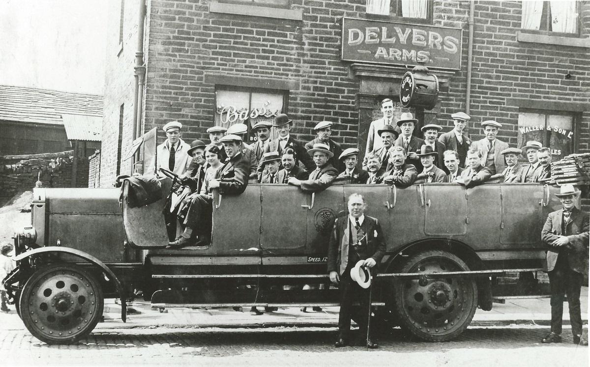
More than churches or chapels, however, the district was full of pubs. Bolton Road had several from the Ring of Bells, near the town centre up to the Delvers and the Prospect. Wapping Road had three: the Union Cross, Richmond House and the Gardeners, the latter once kept by Matthew Hughes, an early recipient of the Victoria Cross in the Crimean war. All those pubs of course had their dark side in drunkenness, violence and neglected families but were essential to sociability, at least for men.

But although, as Mr Sadler remembered it to me, it was ‘a poverty-stricken area’, it had a real ‘communal spirit’.
People would help each other, cooking food, like meat and potato pie for neighbours or lending such as bedding for them to pawn in one of the several pawnbrokers. People sometimes romanticize this spirit in working-class districts but too many former residents testify to its existence for it not to have a core of truth.
But it was still a slum district and was scheduled for clearance after the First World War. Most of the houses were then demolished in the 1930s. Many of the residents were rehoused on the Canterbury Estate, which was built in those years. For long afterwards, large areas were left derelict, waiting for a ring road that finally arrived in the 1980s.
* The Lost Neighbourhoods Project is exploring the histories of 20 areas - including Wapping - that existed in what we now know as Bradford city centre. The project, supported by an £8,000 Lottery Heritage Fund grant, is carrying out interviews with people who remember these districts, with the aim of producing a series of videos.
Says Jonathan Crewdson from the Lost Neighbourhoods Project CIC: “We’d like to talk to people who lived, worked, volunteered, owned property or a business, or had some other connection with any of these neighbourhoods, or are familiar with them for some other reason. We’re especially interested in people who lived in or close by these places after the Second World War as we wish to capture people’s memories of this period and what it was like to live there. We’re very keen to see any old photographs of these neighbourhoods and the people who lived there.”
A series of ‘discovery sessions’ across these neighbourhoods runs from today to June 26. The informal discussions will giving people chance to reminisce and share stories.
Todays’s sessions are: Birksland & New Leeds, 10am-12noon at Millside Centre, Grattan Road; Holme Top, 2pm-4pm at All Saints Landmark Centre, Little Horton Green. The Wapping session is on Wednesday, April 3 from 2pm-4pm at Bradford Cathedral.
* To find out more contact Jonathan Crewdson on 07422 715910 or email mail@neighbourhoodproject.org.uk


Comments: Our rules
We want our comments to be a lively and valuable part of our community - a place where readers can debate and engage with the most important local issues. The ability to comment on our stories is a privilege, not a right, however, and that privilege may be withdrawn if it is abused or misused.
Please report any comments that break our rules.
Read the rules hereLast Updated:
Report this comment Cancel