
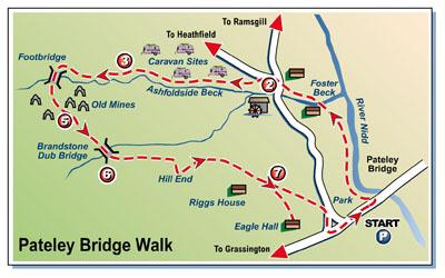
One of the main leisure activities of modern times, caravanning, rubs shoulders with the remains of industries of yesteryear in this very pleasant outing from Pateley Bridge, in the heart of beautiful Nidderdale.
It's a most enjoyable six-mile saunter up an increasingly steepening valley to the debris of a centuries-old lead-mining industry (although the bulk of the remains are from the 19th century, when Providence Lead Mines were hugely productive) and back over the top to Pateley Bridge via a good track and then narrow, winding road which offers some superb views.
I was up and off from Bradford early, parking up in the town's main car and coach park by 8.30am and setting off through the park alongside the river, heading upstream.
Within minutes I was walking past the first of several caravan parks I was to find along the route, exchanging greetings with a couple of dog walkers heading in the opposite direction, each responsibly clutching a plastic bag of poo.
The path led out into an open field then diverted away from the slow-flowing Nidd to head towards a farm and a footbridge across Foster Beck, the watercourse I was to follow for the next hour (although largely under a different name).
Reaching the road just opposite a T-junction, I made a brief detour left to have a look at Foster Beck Mill which was producing linen until the mid-1960s when it became the Watermill Inn, still sporting the 34ft-diameter water wheel that produced the energy to drive the machines.
The mill/inn is now apartments and the house next to the road, where the mill manager used to live, has become The Bridge Inn - rather aptly, as it stands beside the bridge!
I retraced my steps to the junction and turned left up the lane, soon taking the left-hand fork which promised access to various caravan sites. It was a pleasant stroll up through the virtually consecutive camps which lined the lane for the next couple of miles - large travelling caravans with attached awnings of matching size and even larger static mobile homes.
Nice sites these, in a lovely, leafy position with the beck bubbling past. Except it wasn't Foster Beck any more. It had become Ashfoldside Beck, though it was just as pretty and became even prettier as the lane left the caravans behind and rose above the tumbling water on the way to the head of the valley through fields of grazing sheep.
Eventually a signpost pointed the way down to what I had been led to believe, by someone who had walked this way a couple of years ago, would be a ford. Instead I found a sturdy new timber footbridge. There is no longer any need to avoid this outing after spells of rain.
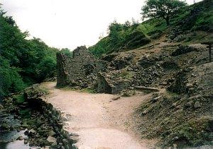
Across the bridge the path picked its way round and across the relics of that mining industry: the spoil heaps and the ruins of the smelt mill with bits of its flue still evident up the hillside, the rusting remains of pit-head machinery, the crumbling stretches of stone wall that were once part of an industry which began here with the Romans.
This is dangerous territory. Signs warn about deep shafts. It's advisable to stay close to the path, which I did as I zigzagged towards a tall, narrow wall surviving from one of the buildings and found myself joining a broad, clear track which headed steadily up the hillside.
I was walking away from the mines now, following the Nidderdale Way sign to cross Brandstone Beck (the other tributary of Foster Beck). The track soon became a lane which continued past a couple of farms on the way to the broad ridge of Ladies' Riggs and some fine Nidderdale views before dropping down to Pateley Bridge again.
The last quarter mile of the walk was via field paths, passing the remarkable collection of impressive buildings known as Eagle Hall before dropping down into the streets of the town to return to the beginning.
Here I met another dog-walker, the only other person I had seen on foot since those two carrying their plastic-bag burdens at the start of the two-hour trek.
Step by Step
- From car park on western side of bridge at Pateley Bridge, cross road into park and walk up embankment beside river. Carry on past caravan site and across fenced crossing path. Soon leave river to fork left across field to pass to right of Brigg House and go over footbridge. Follow beckside for a while before it curves away. Keep ahead to stile into road at T-junction.
- Go left briefly to look at mill and waterwheel then return to junction and turn left. Soon take left-hand fork towards caravan sites. Keep on main lane through these, ignoring forks off to left and right, until caravans (and, briefly, beck) are left behind as track (Nidderdale Way) swings right and climbs.
- Follow track left through gate and several more gates with Ashfoldside Beck down in valley to left, climbing eventually to point where signpost indicates descent to footbridge over beck and mine workings beyond.
- Over bridge go left, following footpath past ruins of smelt mill with surviving arch then turning sharp right to climb and cross path of old flue before picking way across spoil heaps to meet diagonally climbing wall. Turn left and follow this past warning sign for deep shaft, heading for tall stand-alone wall. Go to left of this to meet broad track and follow it to wide gate-gap in wall.
- Keep ahead on this track, following sign to Pateley Bridge and Toft Gate then at fork following descending track signed Nidderdale Way. Pass entrance of Sun Side Farm and cross Brandstone Beck via Brandstone Dub Bridge.
- Continue along gently climbing track to pass Hillend Farm. It swings right then left over stream and meets metalled lane to climb to ridge of Ladies Riggs. Continue past Riggs House Farm on right and soon look for footpath sign going left off track in trees to stile.
- Go over stile and head down field with fence/ hedge on right to gate at bottom, with Eagle Hall up to right. Continue down fenced path to lane that descends to road in Pateley Bridge. Turn right here, then at main road go left and follow pavement back to start.
Fact File
- Set-off point: Riverside park in Pateley Bridge, on west of river.
- Time for 6-mile walk: two to three hours.
- Going: easy apart from a scramble over spoil heaps.
- Map: OS Explorer 298 Nidderdale.
- Getting there: Getting there: drive past Leeds Bradford Airport on A658 to Pool. Go over bridge and take first left to go through Leathley on B6161 to Killinghall, joining A61 to Ripley. Turn left there on B6165 to Pateley Bridge Parking: pay-and-display car park alongside showground, near park.
- Refreshments: pubs and cafes in Pateley Bridge and Bridge Inn not far from start of walk.
- Toilets: on edge of park by river (none along route unless you're cheeky enough to use those at one of caravan sites)


Comments: Our rules
We want our comments to be a lively and valuable part of our community - a place where readers can debate and engage with the most important local issues. The ability to comment on our stories is a privilege, not a right, however, and that privilege may be withdrawn if it is abused or misused.
Please report any comments that break our rules.
Read the rules here