

Country walking isn't all about strolling along in a relaxed sort of way and admiring the scenery, you know. As in most other areas of life, there are important decisions to be made. Such as whether to proceed or go back when you come to a sign advising you that there are bulls and suckling cows with calves in the fields ahead.
The walk published a couple of weeks ago through arable farmland didn't throw up a cattle problem until almost at the very end. This one, in grazing countryside, turned out to be a bit different.
But to begin at the beginning, which took place in the visitor-centre car park in Malham just before nine o'clock on a midweek early-June morning. The sky up there was bluer and brighter than it had been when I left Bradford, and the air warmer.
I soon slipped off my jacket as I left the village and walked southwards through the fields, following the Pennine Way sign. Soon I reached the point where Gordale Beck and Malham Beck join forces and flow together very briefly before being augmented by another tributary which gives their combined waters a new importance and a significant name.
The River Aire rises from the earth at two adjacent points in a field between the footpath and the road, links up with the becks and proceeds southwards and westwards, growing all the time until it becomes the wide waterway we in West Yorkshire know and now love rather better than we did when it was so badly polluted by industry and effluent.
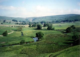
Up there, though, the waters are sparkling. The embryonic Aire flowed prettily down in the valley to my right, with llamas grazing in the fields beyond, as I followed the path around the hillside through fields of sheep, climbing steadily. Cattle sat sleepily in the distance at the top of the field.
At a wall corner, the path began its steady descent to a gate beyond which a lone horse stood stock still with its back to me. I walked past it, trying not to startle it. It never moved. Perhaps it was asleep on its feet in the sun.
I followed the quiet lane down through the hamlet of Hanlith, where a plaque apparently depicting St Francis adorns a wall on the side of a house opposite the splendid Hanlith Hall, and strolled on into Kirkby Malham between verges bright with early summer flowers against a backdrop of mossy limestone walls.
Nobody was around. With the exception of the few remaining farmers, these Airedale villages now appear to be dominated by commuters, ramblers and tourists.
I left the main road on the bend and took the Settle road (Cow Close Lane, which was to turn out to be an apt name) beyond the church, soon climbing steeply between fields.
Then came the problem. My route forked off from the road, over a stile beside a gate to which were attached two notices. One warned that suckling cows with calves were grazing in the fields ahead. Another added that there were bulls as well.
The field immediately ahead was home only to sheep, so I followed the broad track along to where a footpath sign pointed into another field - a large, wide one, with the path heading straight down the middle of it. There were plenty of cattle in that one, and in the fields beyond as well.
Here was the time for decision-making. Should I gamble on the cows not seeing me as a threat to their calves and leaving me alone, and there either being no bulls or only docile ones?
My dodgy hip is OK for walking with the help of a couple of precautionary paracetamol tablets but it isn't up to the challenge of a sprint to safety should the need arise. I decided against proceeding and made this one of those very rare occasions when I retrace my steps.
It turned out not to be a bad decision. The route in reverse afforded some attractive views, including that of Malham Cove as I took the Pennine Way northwards. And the lone horse was still there, deep in its standing-up slumber.
Step by Step
- Leave car park, pass entrance to visitor centre and turn left briefly towards centre of Malham, soon going right to cross Malham Beck and turning right again to walk downstream. Go through one gate, then another, and at third gate follow Pennine Way sign into field.
- Follow clear path ahead past water-treatment works on right, passing confluence of Gordale Beck and Malham Beck. Before River Aire joins the flow, the path starts to climb above it to a stile, then dips before climbing again to another, then arrives at a wall corner with a finger post. Turn left here, but veer away from wall on left to follow grassy path towards a gate just to left of a house. Through this, continue to gate stile into road.
- Follow right-hand, descending fork of road through hamlet of Hanlith and on to cross bridge and continue into Kirkby Malham opposite Victoria pub. Turn right and walk along through village. Where main road turns sharp right, go left following Settle road sign.
- Walk along road, passing church on left, and climbing steeply as road curves round to right then eventually swings left. Soon arrive at a gate with a stile beside it and a "Malham 1 miles" finger post and cattle warning sign. Here you must decide. Either go back as I did or..
Bear in mind that what follows is taken from the map, not from actually walking it.
- Go over stile and walk along track to point where signpost points right down wide field. Follow path down this and into another field, crossing footbridge over a stream at corner of plantation. Continue round left-hand side of trees through a succession of fields, swinging right (east) to pass through another stile at another spur of woodland and then another to head across a wide field with wall to right and join lane that descends into Malham near car park.
Fact File
- Start: Malham car park
- Time for walk: 1-2 hours
- Going: Easy apart from a couple of uphill pulls
- Map: OS Yorkshire Dales Southern Area
- Parking: Pay-and-display in Malham
- Public transport: check with www.dalesbus.org
- Toilets: At Malham car park
- Refreshments: In Malham, plus pub at Kirkby Malham


Comments: Our rules
We want our comments to be a lively and valuable part of our community - a place where readers can debate and engage with the most important local issues. The ability to comment on our stories is a privilege, not a right, however, and that privilege may be withdrawn if it is abused or misused.
Please report any comments that break our rules.
Read the rules here