
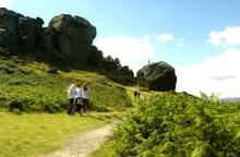

The Wharfe valley was shrouded in mist as we pulled into the Cow & Calf car park before 9am on a spring day. Somewhere below us Ilkley was beginning to bustle. Nearby a cuckoo called. Above us the occasional patch of blue was visible in what was otherwise a solid cloud ceiling.
The moor didn't look very inviting as we walked up the path towards the Cow then climbed to the left to walk round the back of the quarry. The path ahead was clear enough, though, leading off through the greyness to cross a pretty stream tumbling over stone steps and climbing steeply to the cairn above Ilkley Crags.
This was to be a walk of stones, passing a succession of relics left on the moor at different eras in its long history. Piles of stones, standing stones, stone circles, stone stiles, tumbled stone buildings, stone shooting hides, inscribed bouldersthey were all there along the nearly six miles of the route.
From the cairn we turned to head southwards on the Dales Way, eventually dropping down to cross the narrow stream at Gill Head and as we continued along duckboard keeping our eyes on what initially looked like a solitary figure standing on the skyline.
It wasn't a figure, though. It was a stone post with "IM ILB 1893" inscribed on it. A little further along we came to a feature from a much earlier date: the Twelve Apostles stone circle, no match for Avebury or Stonehenge but fascinating enough in its own right. Who put them there on the top of the moor, and when, and why? We'll never know, because those people left no written record of their lives.
On we plodded, still heading southward, until at a crossing of tracks we came to another stone post, this one telling us that it was "V" miles to Bingley and "II" miles to Ilkley, which some stonemason had later considerately translated to "2". Was it that stonemason who made his mark at the bottom of the inscription, or the earlier one?
It was around this point that we, apparently the only two walkers on the moor that morning, were joined by a pair of Canada geese which flew in a long, low circle around us honking loudly before landing in the burned heather nearby. They were to stay with us for nearly an hour - taking off, circling and landing again, as if they were curious to know what two humans were doing up there on their own on such a grey day.
At one point it seemed they had miraculously been transformed into Greylags, performing the same manoeuvre and landing on the left of us, until we spied the black heads of the Canadas poking above the heather to the right. From then on we had four escorts.
From the milestone a narrow fork off the main path took us across a boggy stretch of moor to a wall stile with a metal gate beside it. The route continued at the other side, passing a large boulder before turning northward to another double stile. The right-hand one was the more interesting of the two, its upright being inscribed with "Thos Pulleyn Horncliffe Well". Beyond it was another standing stone in front of the ruins of what surely used to be a farm. On it was inscribed "W + M Horncliffe Well".
The return path, though, lay via the left-hand stile and followed a wire fence for a while before striking up the moor towards a wooden shelter, passing along the way a line of shooters' hides. Passing the rocky outcrops on the ridge we swung slightly west, heading for High Lanshaw Dam, a small reservoir where we found both pairs of geese settled on its waters and ignoring us as we walked past along the dam wall. This modest stretch of water must at one time have been rather larger, judging by the extent of its stone rim which is now buried in grass.
From the reservoir we headed for a yellow post on the skyline. Not far beyond it we arrived at another rocky outcrop. Inscribed on one of the large rocks was "W + M 1785" with, underneath it, "ILB 1893". Was this the "W + M" of Horncliffe Well and the "ILB" of stone-post fame? It's odd to think of someone labouring away with stonemason's hammer and chisel in this remote spot 222 years ago, making their mark for posterity.
Two more prominent rocks remained on the route: the large, solitary stone which we headed towards before turning down the steep gulley towards the Cow and Calf Hotel, and the Pancake Stone balanced precariously on the moor edge and visible from the descending path.
As we arrived back at the car park the sun came out and the grim moor glowed welcomingly. Isn't that just so often the way of things?
Step by Step
- From Cow and Calf car park, walked up flagged path towards quarry then turn left up another stone path to curve round to right above top of quarry. Take broad path forking leftwards across moor, crossing stream and climbing to Ilkley Crags.
- At cairn near crags, turn left on to Dales Way. Where path forks, follow left-hand route to cross Gill Head stream. Keep ahead on duckboarding, heading for standing stone on skyline. From here, continue to Twelve Apostles stone circle.
- Continue south along main path, passing another stone post at junction of tracks and soon afterwards forking left on narrower path, heading for wall in distance. At wall, go over stile and keep ahead with path, swinging leftwards and passing large boulder before turning left again to return to wall at double stile.
- Go over left-hand stile and walk ahead with fence on right. Path eventually veers away from fence, passing grouse butts on way towards wooden shelter on skyline and rocky outcrop to left of this. Pass outcrop and soon meet crossing path. Turn left here briefly, then soon go right to walk along edge of High Lanshaw Dam and swing left at far side, heading for yellow marker post on skyline.
- From marker, keep on to another and to further outcrop with inscription on large rock, then continue with path, heading towards another large rock but turning right well before it to go down rocky gulley in direction of Cow and Calf Hotel (with Pancake Stone up to right). At crossing track go left to Cow and Calf rocks and return to start.
Fact File
- Start: Cow and Calf rocks
- Time for 5-mile walk: 2-3 hours
- Going: steady with one steep uphill pull
- Map: OS Pathfinder Keighley & Ilkley or Explorer 297 Lower Wharfedale and the Washburn Valley
- Getting there: Bus or train to centre of Ilkley then walk up Wells Road and cut across moor bottom past Ilkley Tarn to Cow & Calf rocks (adds a couple of miles to return journey).
- Parking: Cow and Calf car park.
- Toilets: In centre of Ilkley (main car park).
- Refreshments: Ditto, and at Cow & Calf Hotel.


Comments: Our rules
We want our comments to be a lively and valuable part of our community - a place where readers can debate and engage with the most important local issues. The ability to comment on our stories is a privilege, not a right, however, and that privilege may be withdrawn if it is abused or misused.
Please report any comments that break our rules.
Read the rules here