
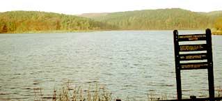
Ogden Reservoir - and the woods and moors around it - is one of my favourite places for short walks.
It has everything: an attractive stretch of water with a woodland backdrop; newly-created forest trails; wide-open views from the track leading up past the golf course to the Withens pub; a delightful valley of Ogden Clough down which the stream’s waters cascade over a series of stone shelves; and a windfarm to delight or offend the eye depending on how you feel about these things (put me down as a “delighted”).
This walk actually found me heading into territory that was new for me, walking away initially from the reservoir and its trees and the whooshing wind turbines into the valley below the reservoir dam.
I did this walk on a Thursday morning in mid-November, while the ground was still drenched after the heavy rains. Everywhere was soggy underfoot, sometimes unpleasantly so. But nevertheless, it was a splendid outing.
The forecast wasn’t a bad one, at least for the morning, though when I set off from the Ogden car park at half past eight there were plenty of worryingly dark clouds around towards the west (which was the direction the weather was coming from).
“Nice morning,” I cried optimistically to the countryside warden in his hut.
He cast an eye towards the sky and said: “Don’t bank on it staying that way.”
My route took me at first along the dam and then headed left to splash along the path skirting the golf course. The views from here were pleasant enough: down across Mixenden Reservoir and beyond towards Sowerby Bridge, with Halifax towards the left. They were to get better, though.
I dropped down towards the stream, with the golf clubhouse beyond. Surprisingly, there was not a single golfer in sight. Usually, however early I’m up and about, some of them have beaten me to it.
I walked downstream before turning away from the running water to soon find myself plodding through plenty of standing water, ankle deep in mud. The ground clawed at my boots as I crossed a field and then followed a fenced path to emerge in a lane near a bridge.
And that was when the warden’s warning came true. The heavens opened. I turned my back towards the wind-blown rain and sheltered as best I could beneath almost leafless autumn trees. In ten minutes it was over and I was off again: walking through the handsome houses of Stod Fold, splashing up a field, and then leaping from one causeway slab to another up the next field.
They have colourful names around these parts. Slaughter Gap was to my right as I climbed the steep Hunter’s Hill towards the disused quarry workings and the quarry track which led between them. It was an interesting landscape up here, with sheep grazing on the grassed-over mounds of quarry spoil and, when I stopped and looked back across the valley, the landmark of Soil Hill.
At the end of the track, a gate led out into the high ridge road that runs from Wainstalls to Oxenhope. Immediately below was Leadbetter Dam and High Cote Dam (home of Halifax Water Ski Club). Beyond it was Calderdale with the folds of the Pennines and, in the distance, the distinctive dagger of Stoodley Pike.
The views all round were incredible and uplifting as I walked on top of the world along this ridge road beneath a dramatic sky of boiling clouds to the Withens Inn (the highest in Yorkshire, is its claim).
From there I took the flint track back down past the top of the golf course towards the reservoir. The golfers were by now out in strength.
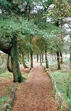
The track was a bit hard on the ankles, so I was glad of a chance to leave it and head down through the woods on newly-made paths beside a trickling stream to meet the reservoir side and walk along it back to the start.
Despite the warden’s gloom, the rain had largely stayed away and it had been what I said it would be - a nice morning.
Step by Step
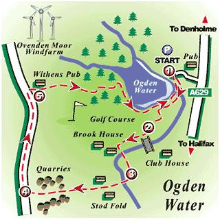
- Leave car park at Ogden Reservoir and walk across dam. Go through gate at far end and almost immediately take signposted path to left. Don't take rising green path right-ish at fork near start. Instead, keep on along more-or-less level path that soon curves round to right, ignoring narrow paths dropping down to left. Curving path becomes straight, grassy path descending gently to pass to right of wall end and meet cinder track. Turn left down this briefly then follow grassy path down past golf green to stone shelter.
- Go left down track towards footbridge with clubhouse beyond. Don't cross bridge but instead turn right on side of beck. With farm ahead, go left over concrete bridge into lane. Swing round to right, through metal gates and past Brook House Farm, turning left up lane with water trough on left and, soon, narrow gap stile on right. Through this stile, veer away very slightly from wall on right towards entrance to path between wall and wire fence (could be muddy after heavy rain). Walk along this path, turning right at far end with plantation on right, then going left over stile into farm lane.
- Turn right to cross bridge and walk up lane, between houses of Stod Fold, to go through metal gate into field, Walk up field with wall on left to fence stile and then, almost immediately, wall stile. Keep ahead along intermittent stone slabs to gate stile into lane. Go left here, and then soon right following waymarkers up hillside (Hunters Hill) to swing leftwards with line of smallish trees and go between stone pillars into walled track. At top, follow track round to right and stick with it between quarry spoil heaps to eventually arrive at gate into road.
- Turn right her and walk along road to Withens Inn, going right through car park and through gate into track leading back to Ogden reservoir.
- Pass a couple of signposted paths off to left, on to moor, to come eventually to stile on right just past start of trees, bearing "No Cycling" sign. Go over this and ahead to meet woodland trail path. Turn right down this, with stream on right, to T-junction. Go left here, then soon swing right to stile on to side of reservoir. Turn right along reservoir to return to dam and restrace steps to car park.
Fact File
- Time for 4½-mile walk: two hours.
- Going: one uphill pull, otherwise easy - but can be muddy in places after heavy rain.
- Map: OS Outdoors Leisure 21, South Pennines.
- Getting there: drive up through Thornton then go left of Denholme-Halifax road, turning right along lane to Ogden Reservoir near Whole Hog pub.
- Buses: First Calderline 502 from Keighley to Halifax, getting off at Causeway Foot. Or Keighley & District 697/699 from Bradford Interchange to Denholme Gate, walking from there to and from start (adding a mile to distance).
- Parking: at reservoir.
- Toilets: at reservoir, opposite information centre


Comments: Our rules
We want our comments to be a lively and valuable part of our community - a place where readers can debate and engage with the most important local issues. The ability to comment on our stories is a privilege, not a right, however, and that privilege may be withdrawn if it is abused or misused.
Please report any comments that break our rules.
Read the rules hereComments are closed on this article