
One of the nice things about walking is that it takes you into the back streets and by-ways of towns and village you've only ever seen from a car before, driving along their main through road. You get a false impression from the driving seat that what lines that road is all there is. But stop for a while and walk about, and those villages broaden out.
There is life behind the backdrop of pubs, cafes and gift shops. There are streets of pretty cottages heading off into the countryside, and small, well-kept estates of houses. There are hidden car parks, village halls and churches.
Gargrave is a case in point. In all the hundreds of times I've driven through the village, I've admired it but never stopped to have a wander around it. We put that right on a sky-blue Saturday when the air was fresh, the distant views sharp, and a cheek-numbing wind was blowing from the East.
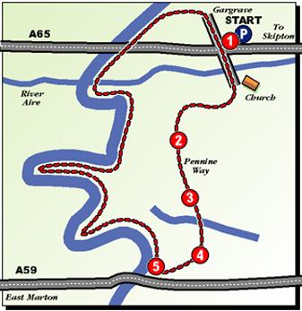
On our way from the car park, and back to it by the (different) return route, we discovered that Gargrave is a pleasant, three-dimensional place worth a pause on the way to the Dales or the Lake District. It's also a good starting point for an easy, enjoyable seven-mile walk which returns by the highest and most attractive stretch of the Leeds-Liverpool Canal.
Our route away from Gargrave found us heading along a paved lane towards a farm and joining the Pennine Way. The path was far from well-trodden, though clearly waymarked, as we picked our route through a succession of fields towards East Marton.
We had just one bull scare. In one of those fields a herd of cows was walking away from the path and they all ignored us. But as we crested the ridge and saw the route ahead, standing next to the path was another beast - a young bull with curly top-knot and a ring through its nose. And Maureen was wearing a bright red jacket!
There was nowhere to go but ahead if we wanted to complete the walk. So we strode past the bull, feigning nonchalance but braced ready to race for the gate. It was staring up the field after the cows, lost in thought, and took no notice of us. As we drew closer to East Marton, gunshots shook the air several times from the woodland fringing the fields. Some sort of hunt was clearly under way. It was a hunt of another sort that we spotted later on. We had walked along the canal from East Marton with its moored pleasure boats, following its meandering, U-turning route along the contours of the land on the way to the attractive Bank Newton locks and admiring the rotating views of the top of the world until we eventually found ourselves facing Cracoe Fell, Flasby Fell and Embsay Crag.
There is still a vast amount of open space in this glorious county of ours, away from the city and suburbs. And in the distance a line of horse riders, some in hunting pink and accompanied by barking dogs, were galloping across some of it and vanishing over the hill top. We, meanwhile, tally-hoed for home. As we reached the first of the strung-out Gargrave locks, the smell of frying chips wafted towards us. The popular Anchor Inn at Gargrave was still a quarter of a mile away but the wind was in just the right direction to tempt hungry walkers. We resisted. We were too spattered with mud from the fields stretch of the walk to be socially acceptable. Instead we made our way back to Gargrave and changed our footwear, and went for lunch to the Merry Mason close by the church instead. And very nice it was too.
Step by Step
- Start walk at far end of Gargrave from Bradford, crossing bridge over River Aire in direction of church. Turn right immediately across bridge and follow paved path in front of houses to emerge into residential road. Turn left, then right at T-junction (Marton Road) and soon left again following East Marton footpath sign up paved farm track. Path soon become Pennine Way and crosses railway line. Eventually it reaches cattle grid and veers right down to Scaleber Farm.
- From cattle grid, go ahead across field to meet another track briefly on way to a direction post. Keep ahead from there to kissing gate and continue with fence on right to another stile. Turn left down to bottom corner of field, then right to another stile (keeping to right of fence). From here go ahead down field to stile beside gate over Crickle Beck.
- Turn right over stile and follow field side with fence on right to stile beside a gate, then follow fence on left until it turns sharply away from path. Keep ahead on narrow path to soon descend to stile and plank footbridge. From far side, go very slightly left up field and on to stile in bottom corner into lane.
- Walk left along lane to broken stile on left next to green gate. Go across field to another stile into short walled lane to left of wood and disused quarry. At top of lane, over another stile, veer right with wood edge. When boundary swings sharply to right, go slightly left to stile in field corner into lane. Turn left to meet canal at East Marton.
- Join canal towpath and turn right, following it back towards Gargrave. At Bank Newton route joins road briefly and crosses canal. Swing left over stile and under bridge to return to towpath. Where a similar road detour occurs closer to Gargrave, swing right then go under bridge to towpath. Near Anchor Inn locks, follow towpath under main road and at next bridge leave towpath and turn right to return to start.
Fact File
- Time for seven-mile walk: three hours.
- Going: easy.
- Map: OS Outdoors Leisure Yorkshire Dales South.
- Parking in Gargrave: drive through village then follow car park signs to right. If first car park is full, try next one.
- Refreshments: pubs and cafes in Gargrave, and Cross Keys pub at East Marton (cross canal and follow lane to road, then turn right).
- Toilets: in Gargrave next to bridge over river.


Comments: Our rules
We want our comments to be a lively and valuable part of our community - a place where readers can debate and engage with the most important local issues. The ability to comment on our stories is a privilege, not a right, however, and that privilege may be withdrawn if it is abused or misused.
Please report any comments that break our rules.
Read the rules hereComments are closed on this article