
It was yet another grey day in a winter which seemed to have more than its fair share of them. When the mist is down, there's no point heading for high places and being disappointed when you can't see the views. Far better to stay down in the valley and look for non-scenic interest.
So I found myself heading for Huddersfield and a walk through an industrial and suburban landscape, with a token bit of countryside for variety.
It wasn't the sort of outing to lift the spirits, but there was plenty to see along the way – even if a lot of it was far from attractive due to the messy, litter-spreading, graffiti-scrawling, car-burning antics of urban humanity.
This was a five-mile stroll from the centre of Huddersfield, a route recommended by John Morrison in his guide Walks From the Kirklees Way (Leading Edge publications). If you're not familiar with an area, a book like this is an invaluable starting point, rather than sitting down with an OS map and trying to work out a route from scratch.
The walk began at Huddersfield's magnificent station, which with its Corinthian columns looks rather more like a museum or opera house. Its style reflects Huddersfield's 19th century sense of self-importance, which was fully justified. Some of the finest worsted cloth in the world has come from that solid town.
I wandered through the busy streets of the lively town centre towards the ring road, noting the lunchtime menus just being posted outside the opening pubs. Huddersfield, I reckon, must offer some of the cheapest pub lunches in the country. I was sorely tempted, but I'd just devoured a cheese sandwich in the car park, and there was another waiting for me when I got back there in a couple of hours. And in between there was a walk to do.
I crossed the ring road and headed for the canal basin, where boats were wintering on dry land and a pub-restaurant's outdoors tables waited for summer customers. I struck north along the Huddersfield Broad Canal towpath, wishing Bradford had never lost its own waterway link with the Leeds-Liverpool canal. These strips of water are now a major attraction. Huddersfield's has been incorporated into landscaping for the town's Sainsbury's, with seats and waterfront walkway running alongside the store.
The canal was lined with industry; some of it old, some of it new. Before long I came upon a splendid example of 19th century engineering ingenuity: a bridge, built in 1865, lifted still by a system of wheels and pulleys when boats need to pass through.
Before long I was out of the mills and factories and into relative countryside, pounding the towpath past locks and bridges before crossing the canal and striking uphill with a large school on my left. The track was strewn with discarded crisp bags and cans. Where the track crossed a railway line, the bridge was colourful with graffiti and two burned-out cars sat forlornly on their wheel-less bellies.
Before long I was pounding pavements or snickets, which is what much of this walk involves. Houses and factories, garages and greenhouses. Then, at last, a glorious panorama right across the town.
Except it wasn't. From a stile into a field high above the town, I could just make out the outline of Castle Hill opposite, and I could see the impressive, modern arches of the McAlpine Stadium – an asset of which Huddersfield people have every right to be as proud as their Victorian forebears were of the station. The rest was lost in mist, which was a shame because on a clear day this would be the highlight of the walk and more than make up for the depressing bits.
Step by Step
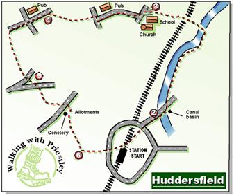
- Leave the station and walk along Railway Street towards the town centre. Cross Westgate and keep ahead, then go left down Cloth Hall Street into King Street. Keep on down to ring-road roundabout, going left slightly to crossing place and crossing towards Sainsbury's petrol station. Turn right and walk on pavement with Sainsbury's car park on left down to canal basin.
- Cross arched bridge towards Aspley pub and turn left onto towpath. Follow canal past Water Street bridge with its mid-19th century lifting mechanism and keep on to pass two sets of locks. Just past third set, turn left over bridge. Walk up track, crossing railway and skirting burned-out cars and climbing to eventually reach road.
- Turn left, and left again at school. By church, cross road and go up Ashbrow Road. With Belle Vue pub on right, go left at T-junction and walk down to junction with dual carriageway. Cross (with extreme caution) to redundant filling station on far side, turn right and walk up hill briefly towards steps with white handrail. Take path to right just at foot of steps and walk on through wood and then over open land. Where path forks, keep ahead to climb past cottages and up steps to road.
- Turn left and walk up to crossroads with Shepherds Arms pub on right. Cross road and continue up North Cross Road to top. Turn left here on track (Coach Road) for a few yards, looking for waymarked stile ahead. It's from this point that you should be able to enjoy fine views on a clear day. Follow path down field to stile in bottom left corner, and turn right to follow road down hill to T-junction. Dogleg briefly left then right to follow bridleway sign down snicket to cross end of cul-de-sac road and become a snicket again to next road.
- Cross over and walk up Storths Road. Where road swings left, keep ahead on unmade road past garages. Cross road at far end and dogleg right then left, passing horse trough with plants before turning into snicket between walls. At far end, emerging at car park, go sharp right up another snicket. Ignore right fork off this and keep on to road. Turn left to main road (with cemetery at far side) and cross over. Turn left, then go right up another snicket between cemetery and garage. Keep on past allotments. Turn right with cemetery boundary, but then take path forking left to pass some more allotments and then go between the school and playing fields to pass Oxley Stables and meet road.
- Turn left, then go left again down Belmont Street. At bottom, keep ahead on track and path through car park to ring road. Cross over and walk ahead back to station.
Fact File
- Time: two-and-a-half hours for five miles.
- Going: easy, but a couple of uphill pulls.
- Map: OS Pathfinder 702, Huddersfield & Marsden.
- Parking: at various pay-and-display car parks in Huddersfield, including some near the station.
- Refreshments: Lots of cafes and pubs in Huddersfield, and several pubs on route.


Comments: Our rules
We want our comments to be a lively and valuable part of our community - a place where readers can debate and engage with the most important local issues. The ability to comment on our stories is a privilege, not a right, however, and that privilege may be withdrawn if it is abused or misused.
Please report any comments that break our rules.
Read the rules hereComments are closed on this article