

Todmorden is a sturdy Pennine town: not lovely, but interesting enough with its solid Victorian architecture and its valley-bottom mix of residential, industrial and commercial properties, its shops, pubs and cafes, it canal and railway and busy, busy A646 road.
Its finest asset is the collection of footpaths that climb up steeply on both sides of the valley, heading for glorious moorland tops with fine vantage points that let you see for miles.
At least, they normally do. And if we had done this walk on the previous day, when the skies were blue and the winter air sharp, that's what we would have enjoyed. Alas, the weather let us down with cloud sweeping in from the west overnight.
When we left Bradford there were still a few patches of blue among the grey, offering hope that things might take a turn for the better. By the time we arrived at Tod the sky was solid grey and a misty rain was sweeping across the town. It was, we were informed by the friend who met us and was to be our guide, a typical Pennine day.
But not to worry. Because of the weather it might not be a very scenic walk we were about to undertake, but it was certainly atmospheric.
We strode away from the town centre alongside the main road to Burnley, detouring briefly through Centre Vale Park which has recently reopened after a major facelift. Back on the pavement again, we walked on to a bus stop with, across the road, a footpath sign pointing the way up Stoney Royd Lane.
That way lay our route, soon leaving the houses behind and heading under the railway line to climb on a good track past a couple of farms. To the left, through the trees, was the craggy bulk of Orchan Rocks. We turned our backs on them as the track swung eastwards, heading for another farm. Some work was being done here, to improve the track. Unfortunately you can't make an omelette without breaking eggs. "Improving" a track generally means that you have to move earth around. And earth and rain combine to make mud.
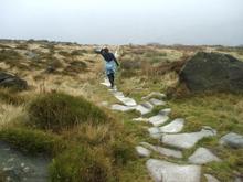
There was plenty of that underfoot for a while as we followed this track up to meet the eastward-running level pegging of the Calderdale Way. The rocks ahead of us now were the Whirlaw Stones, a major Todmorden landmark.
It was good walking now as we left the enclosed path behind, toyed with the idea of digging for the crock of gold at the end of the rainbow immediately to our left, decided against it and veered right-ish. We followed the Calderdale Way across open moorland on an ancient causeway and tried to imagine the packhorses of long ago, their hooves adding to the erosion which wore the deep troughs in the middle of these slabs of stone as they made their way to and from market with their loads of wool or finished cloth.
We made our modest contribution to the erosion before leaving the causeway eventually, taking a narrow farm-access road down the hill past a field corner where a couple of sheep with fat lambs were sheltering from the driving drizzle.
Before long we had turned off the road again and were walking past Todmorden golf course where, of course, the golfers were out. Like walkers, they don't let the elements put them off. Stoodley Park, the most famous of Calderdale's landmarks, was ahead of us now, across the valley.
Soon we arrived at the T-junction and found ourselves in the hamlet of Cross Stone, a collection of rather attractive houses and a disused church.
We walked on past a couple of wells and splendid gardens to pass Bean Hole Head, a yeoman's house dated 1638 carved with the initials "WSJ".
And then we left the road behind again and followed bridleways and footpaths steeply down into the valley for a return to Todmorden alongside the canal.
It had been a damp outing but an interesting one. Hopefully, if you do it the clouds will clear, the sun will shine and you'll be able to enjoy the views as well.odmorden is a sturdy Pennine town: not lovely, but interesting enough with its solid Victorian architecture and its valley-bottom mix of residential, industrial and commercial properties, its shops, pubs and cafes, it canal and railway and busy, busy A646 road.
Its finest asset is the collection of footpaths that climb up steeply on both sides of the valley, heading for glorious moorland tops with fine vantage points that let you see for miles.
At least, they normally do. And if we had done this walk on the previous day, when the skies were blue and the winter air sharp, that's what we would have enjoyed. Alas, the weather let us down with cloud sweeping in from the west overnight.
When we left Bradford there were still a few patches of blue among the grey, offering hope that things might take a turn for the better. By the time we arrived at Tod the sky was solid grey and a misty rain was sweeping across the town. It was, we were informed by the friend who met us and was to be our guide, a typical Pennine day.
But not to worry. Because of the weather it might not be a very scenic walk we were about to undertake, but it was certainly atmospheric.
We strode away from the town centre alongside the main road to Burnley, detouring briefly through Centre Vale Park which has recently reopened after a major facelift. Back on the pavement again, we walked on to a bus stop with, across the road, a footpath sign pointing the way up Stoney Royd Lane.
That way lay our route, soon leaving the houses behind and heading under the railway line to climb on a good track past a couple of farms. To the left, through the trees, was the craggy bulk of Orchan Rocks. We turned our backs on them as the track swung eastwards, heading for another farm. Some work was being done here, to improve the track. Unfortunately you can't make an omelette without breaking eggs. "Improving" a track generally means that you have to move earth around. And earth and rain combine to make mud.
There was plenty of that underfoot for a while as we followed this track up to meet the eastward-running level pegging of the Calderdale Way. The rocks ahead of us now were the Whirlaw Stones, a major Todmorden landmark.
It was good walking now as we left the enclosed path behind, toyed with the idea of digging for the crock of gold at the end of the rainbow immediately to our left, decided against it and veered right-ish. We followed the Calderdale Way across open moorland on an ancient causeway and tried to imagine the packhorses of long ago, their hooves adding to the erosion which wore the deep troughs in the middle of these slabs of stone as they made their way to and from market with their loads of wool or finished cloth.
We made our modest contribution to the erosion before leaving the causeway eventually, taking a narrow farm-access road down the hill past a field corner where a couple of sheep with fat lambs were sheltering from the driving drizzle.
Before long we had turned off the road again and were walking past Todmorden golf course where, of course, the golfers were out. Like walkers, they don't let the elements put them off. Stoodley Park, the most famous of Calderdale's landmarks, was ahead of us now, across the valley.
Soon we arrived at the T-junction and found ourselves in the hamlet of Cross Stone, a collection of rather attractive houses and a disused church.
We walked on past a couple of wells and splendid gardens to pass Bean Hole Head, a yeoman's house dated 1638 carved with the initials "WSJ".
And then we left the road behind again and followed bridleways and footpaths steeply down into the valley for a return to Todmorden alongside the canal.
It had been a damp outing but an interesting one. Hopefully, if you do it the clouds will clear, the sun will shine and you'll be able to enjoy the views as well.
Step by Step
- From centre of Todmorden, head up pavement alongside Burnley Road (A646). Detour left into gate of Centre Vale Park and follow path that runs more-or-less parallel to road to emerge at next gate. Continue up road, crossing by bus stop and heading into Stoney Royd Lane. Walk up this and continue as it becomes wide path between railings.
- Go under railway and follow track as it winds up hill past converted farm on right. With another house soon directly in front, walk ahead to pass along left-hand side of it then swing left and continue climbing up track to T-junction. Go right on to Calderdale Way and walk on, with Whirlaw Stones ahead, to gate on to open moorland.
- Go through gate and follow well-worn, gently descending stone causeway as it passes below Whirlaw Stones on left. At junction just past a farm on right (East Whirlaw), take right-hand, descending narrow road to arrive at bottom of hill with farm track going left and white gate ahead.
- Swing sharp right with road here for a matter of a couple of feet, then fork left on climbing path with field on left. Stick with this path as it goes past Todmorden golf course, with Stoodley Pike ahead in distance. Pass clubhouse on right and join access road, continuing to T-junction at Cross Stone.
- Turn left here and walk on past disused church and houses. Just beyond Bean Hole Head house with 1638 date stone, go right following bridleway sign. Where path meets broad track, go right then soon turn left, again with Stoodley Pike ahead across valley.
- Just before ruined chapel ahead, turn right towards old houses of Rodwell End. Turn left immediately beyond first house on left, then dogleg left/right behind that house to wind down hill on narrow path to emerge at Eastwood picnic site on Halifax Road.
- Walk along road towards Todmorden briefly, then cross main road by first narrow road on left and join canal towpath. Turn right and follow that back into Todmorden.
Fact File
- Start: centre of Todmorden
- Time for five-mile walk: 2 hours.
- Going: easy apart from initial uphill slog.
- Map: OS Outdoors Leisure 21, South Pennines.
- By train: Caldervale Line trains run from Bradford Interchange to Todmorden (every 30 minutes)
- Parking: pay-and-display in centre of Todmorden
- Refreshments: in Todmorden centre
- Toilets: ditto (none along route)


Comments: Our rules
We want our comments to be a lively and valuable part of our community - a place where readers can debate and engage with the most important local issues. The ability to comment on our stories is a privilege, not a right, however, and that privilege may be withdrawn if it is abused or misused.
Please report any comments that break our rules.
Read the rules here