
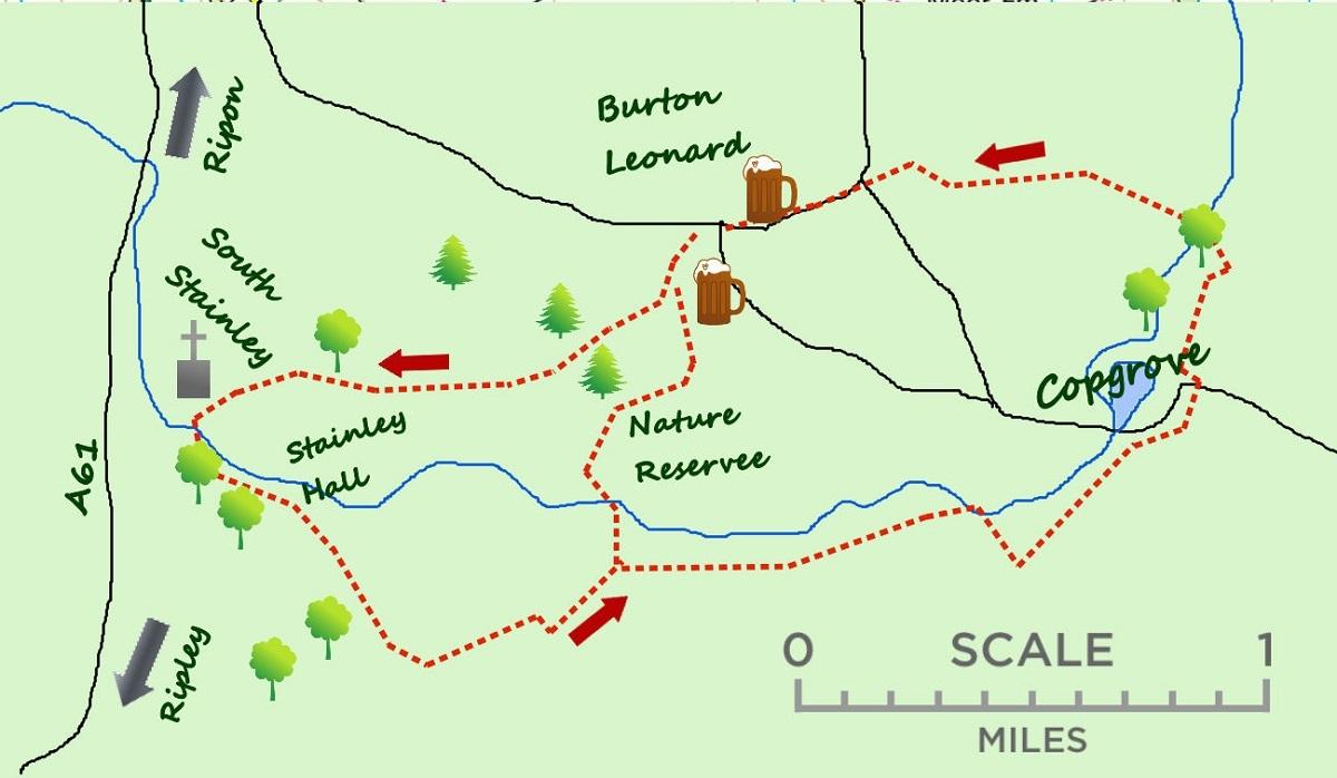

THE walk from Burton Leonard passes through quiet farmland and in to the Mountgarrett Estate.
Although only four miles, it can be easily extended to the pretty village of Copgrove, adding another two miles of easy walking.
To the east of the A61 between Ripon and Harrogate lies some quiet countryside. On arrival at the pretty village of Burton Leonard it is a little disorientating on how best to explore the area. However there are some excellent public footpaths leading to the south west. Burton Leonard is a lovely village with two pubs and an interesting village store set around a village green. It is midway between Harrogate and Ripon. It has a feeling of affluence and occurred to be perfect for those working in either place.
I headed past the school and to a finger sign pointing due west in to the fields. The path skirts some field boundaries before dropping through a wooded path with conifers on each side.
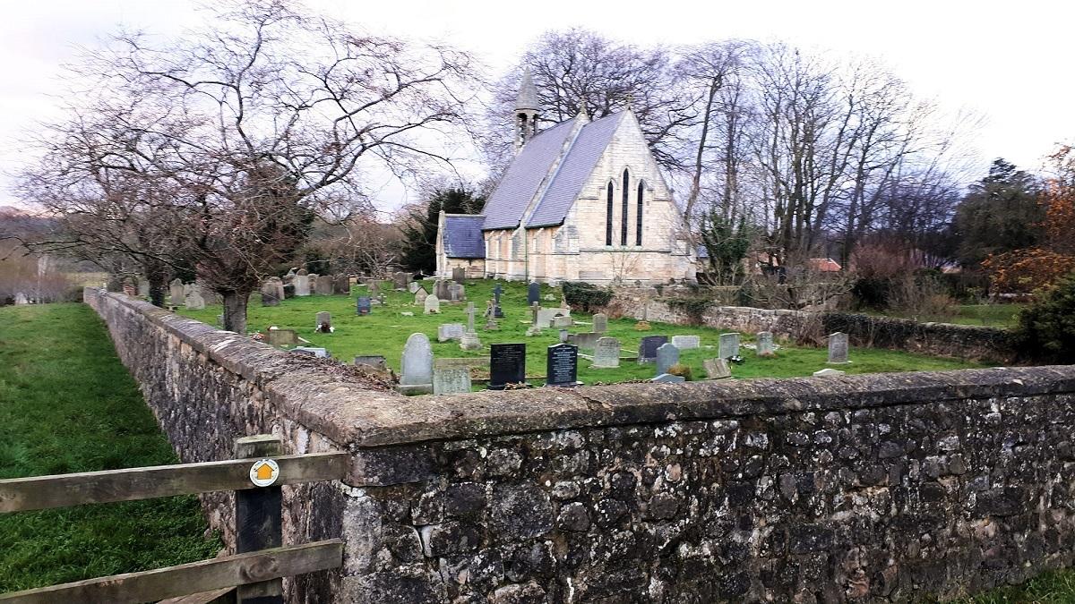
The path drops to a farm track where a permissive path is well signed and followed alongside some more field boundaries. It is a little confusing as the map has this as a Public Right of Way, it did not matter and I soon reached the idyllic village of South Stainley. The first building in the village is the Parish Church of St Wilfrid South Stainley, splendidly sat on some raised ground. It is worth a quick look inside. The village itself is surprisingly small to have such a pleasant church.
Having explored the village, return along the road to the church continuing on the rough lane, leaving the church on your left. After some woodland the lane crosses a stream with some good views across to Stainley Hall Farm.
At regular intervals there are signs that you are walking in the Mountgarret Estate. The Mountgarret Shoot is very popular with pheasant and partridge shoots organised throughout the year. There is clearly other less organised shooting going on around the estate, not always ideal for those with sensitive dogs. A fine story concerning the old Viscount Mountgarret has him fined in 1983 for shooting at some protestors in a hot air balloon with grape shot!
The lane bends to the left half a kilometre from the bridge at the hall and then after a further three quarters of a kilometre there is a choice. The short cut back to Burton Leonard heads left past some old lime kilns, a farm and a small wildlife reserve. However if you carry on for three quarters of a mile to the end of the lane then follow the road left then right you will arrive at the village of Copgrove with an interesting church.
Follow the footpath down to the small stream (a tributary of the River Ure) keeping the woods to your left before doubling back, initially along a footpath but soon a lane in to Burton Leonard.
* Under present lockdown circumstances please do not travel to take this walk. Either walk it if you are local or keep the details handy until it is acceptable to do so.
* Jonathan Smith runs Where2walk, a walking company in the Yorkshire Dales. He has written his own book, the Dales 30, which details the highest mountains in the Dales. He also runs one-day navigation courses for beginners and intermediates.
Join his Learn a Skill, Climb a Hill weekends in the Dales. Visit where2walk.co.uk
Fact File:
Distance: Roughly four miles (extra two miles to include Copgrove)
Height to Climb: 100m (330 feet) although it all seems flat.
Start: SE 327638. I parked alongside the green in Burton Leonard.
Difficulty: Easy. The walk sticks to good lanes with some footpaths. The signposting around Copgrove is less obvious.
Refreshments: The Royal Oak and Hare and Hounds are two excellent pubs in Burton Leonard.
Be Prepared:
The route description and sketch map only provide a guide to the walk. You must take out and be able to read a map (O/S Explorer 298 and 299) and in cloudy/misty conditions a compass.


Comments: Our rules
We want our comments to be a lively and valuable part of our community - a place where readers can debate and engage with the most important local issues. The ability to comment on our stories is a privilege, not a right, however, and that privilege may be withdrawn if it is abused or misused.
Please report any comments that break our rules.
Read the rules hereLast Updated:
Report this comment Cancel