
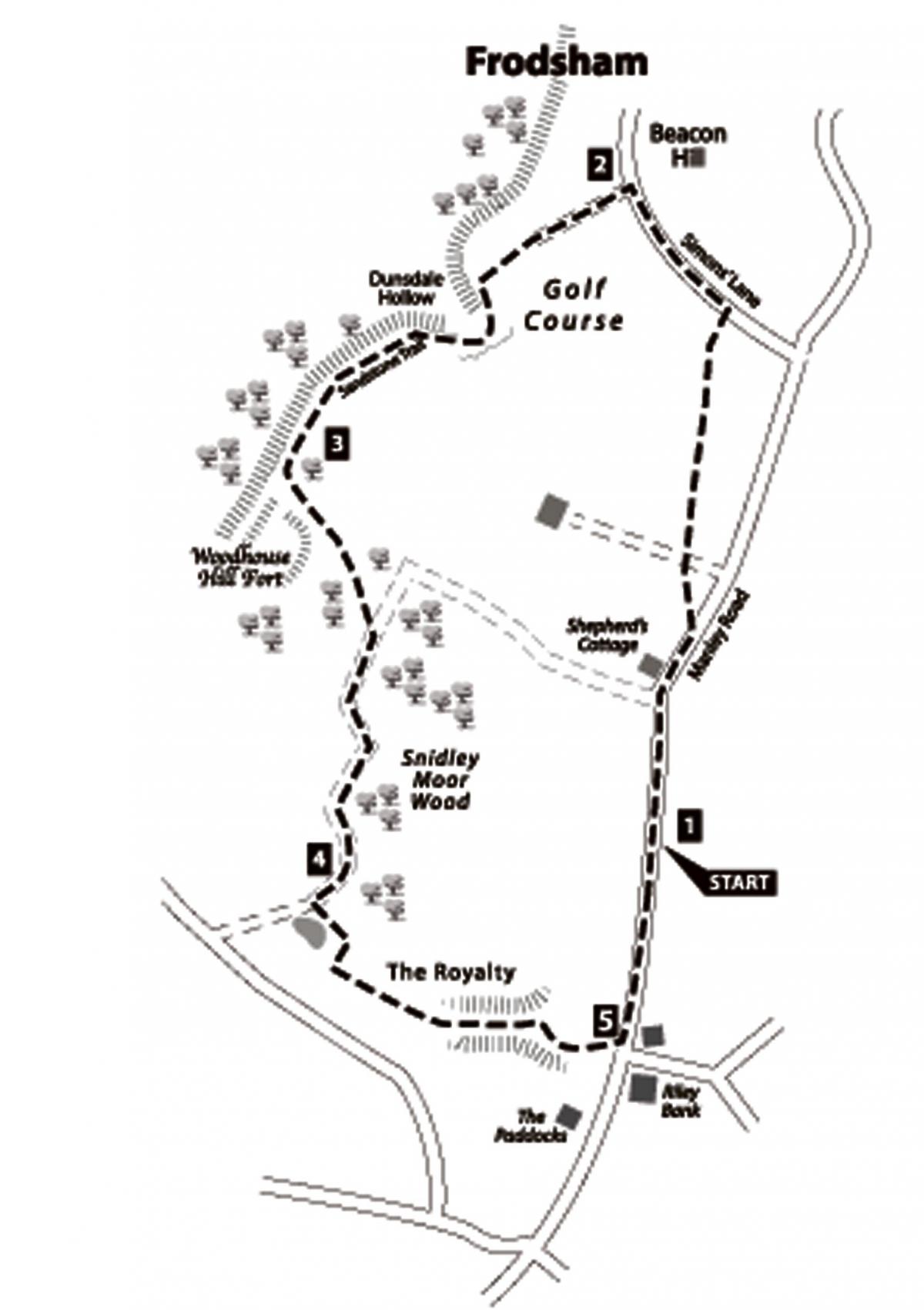
Start: Lay-by between Shepherd’s Cottage and Riley Bank.
Map reference: SJ 519747.
By Car: Take the A56 east from Chester. In the centre of Frodsham turn right onto the B5152. Turn right again towards Manley. Park in a small lay-by on the left after passing Shepherd’s Cottage.
Distance: 4 miles/6.5 kilometres.
Food and Drink: Plenty of eating places in Frodsham.
Map: OS 1:25,000 Explorer 267 Northwich & Delamere Forest.
The walk
1. This is a delightful walk and you will warm up quickly as you turn back uphill. After passing Shepherd’s Cottage, turn left over a stile into a field.
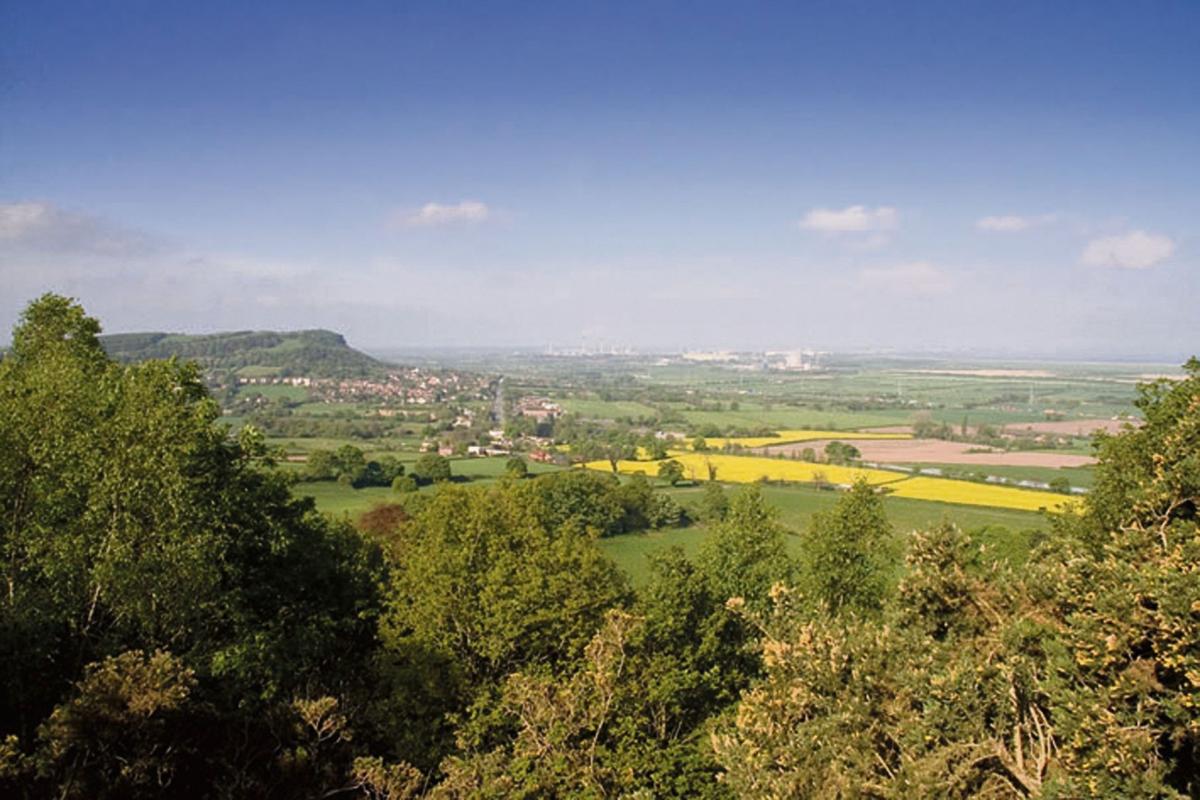
From here you have extensive views of the industrial belt along the Mersey valley. The word ‘Mersey’ means ‘river at the boundary’ and this waterway used to form a natural boundary line between Lancashire and Cheshire.
Cross the field, walking towards the radio masts on the summit of Beacon Hill. Negotiate the high step-ladder stile which drops into the farm lane, then continue ahead on a sheltered path.
Views eventually also open up to the north-east, with Daresbury tower and Runcorn water tower being prominent landmarks.
Cross another stile and continue ahead along a field’s edge. When you arrive at the road turn left to pass Beacon Hill, which has a car park and information about the Sandstone Trail. For the next part of the walk you will be following this trail, defined by a footprint with the letter ‘S’ .
2. Turn left down a footpath, then climb over a stile onto the golf course. Walk straight across this, passing marker posts, then a huge gorse bush, flaming gold in spring. At the far side, drop down into the steep, wooded valley of Dunsdale Hollow.
In recent times a path and steps have been constructed for an easy descent but for many years you had to scramble straight down the sandstone cliff and you can see this route, still known as Jacob’s Ladder, when you look back. (Sadly, the encouraging sign saying ‘NOTSOFARNOW’ seems to have disappeared.)
Bear left at the junction here to clamber out of the other side of the valley, this time by means of huge sandstone steps, conveniently formed in the weathered rock and known locally as Abraham’s Leap. The Sandstone Trail then continues along the hilltop.
The small town of Helsby comes into view nestling under the sandstone crag of its forbidding hill and you can see how the drained marshland below is now used for agriculture.
Keep ahead at the next fork, staying below the brow of the hill until you arrive at a viewpoint from a flat sandstone slab.
A delightful picnic spot, a seat has now been placed here so that you can pick out landmarks at leisure. Liverpool’s liver birds can be spotted as well as the Anglican and Catholic cathedrals behind Hale’s lighthouse - the only one in Cheshire.
On the plain below, Fiddlers Ferry power station belches out steam to vie with the petro-chemical complex at Stanlow, and motorways, canals, bridges, flyovers and railways spread-eagle over the landscape, providing further evidence of the Industrial Age and man’s incessant urge to travel.
3. Continue along the Sandstone Trail, turning left at the next fork to walk round the back of Woodhouse Hill fort.
This is one of seven forts sited along the sandstone ridge of west Cheshire and dates from as far back as the Iron Age. All that is left of the settlement is an earth mound but the early families would have lived in huts, sheltered from the weather by the tree-covered hillside, and with a good vantage point from which to spot sudden danger.
The way can get muddy, but follow it beside a field until Sandstone Trail signs tell you to bear right, dropping downhill. Keep left through Snidley Moor Wood and the path, sheltered below the brow of the hill, is sandy underfoot.
(It can also be boggy.) Evidence of rabbits, badgers and foxes can be found in the sandy banks as you continue along this broad track until the trees on your left finish.
4. Leave the Sandstone Trail at the end of the first field. Turn left through a kissing gate and walk up the side of the field.
The reed-fringed pool has been formed as a blockage prevents water draining away naturally into the valley below.
At the top of the field turn right down a short track, then go left at its end through another kissing gate and continue on a bracken-strewn hillside known as The Royalty. The valley you are now in is an unspoilt, natural delight. Towards its end, veer left and climb steeply up to a field. Then continue along its edge to reach Manley Road.
5. Turn left along the road to complete the walk.
This walk is taken from the book 'Walks in West Cheshire and Wirral' by Jen Darling, published by Northern Eye Books. Copies available online at: www.northerneyebook.co.uk, or from local bookshops.


Comments: Our rules
We want our comments to be a lively and valuable part of our community - a place where readers can debate and engage with the most important local issues. The ability to comment on our stories is a privilege, not a right, however, and that privilege may be withdrawn if it is abused or misused.
Please report any comments that break our rules.
Read the rules here