

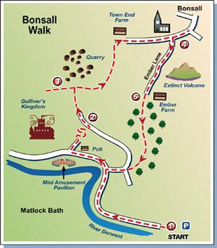
Last time, the walk was to Monsal in the Peak District. This week's goes to the similar-sounding Bonsall, close to that part of the world.
If the valley sides that rise above the Calderdale towns seem steep, those which enclose Matlock Bath in Derbyshire are almost sheer in places. The town is in a tight, narrow cleft through which runs the River Derwent, a railway and a very busy main road.
Cables cars heading for the Heights of Abraham travel in pairs above them all, looking down on canoeists slaloming downstream.
It's a popular spot, a bit like a cross between Hebden Bridge and Knaresborough with even more cafes and a couple of amusement arcades. People flock there at the weekends and for short holidays, to enjoy the ambience of the place or to do what we did: set off walking on one of the many routes that start from the town.
It was relatively quiet in the middle of the Sunday morning as we strolled along from the big car park at the Matlock end, past the station and on to the Tourist Information Centre (which has since closed, its function being taken over by the Mining Museum next door). However, the first of the weekend bikers who congregate here had started to arrive and were admiring each other's gleaming machines.
We crossed the road and turned left to walk up the ramp next to the Fishpond Hotel, arriving at a road at the top. Our route from here led us very briefly into the access road for Gulliver's Kingdom (climbing over a short wall beside the barrier, which was locked) then took us up a steep, long, winding flights of steps up a wooded hillside.
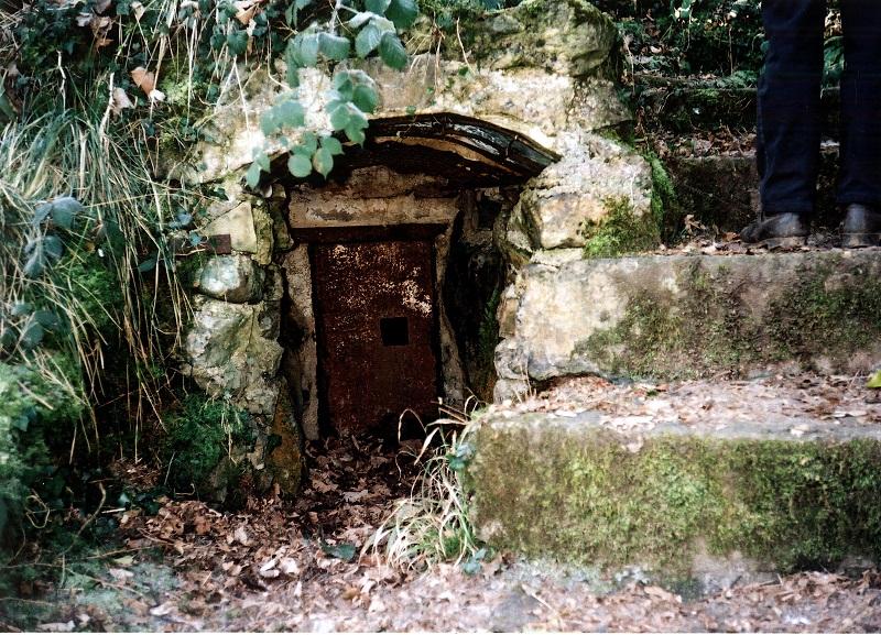
Great exercise, this, for heart and lungs. About halfway up we came across a mysterious, tiny door with a keyhole in the hillside next to the steps. Was it a dungeon for the little people who live among the trees?
Finally we arrived at the top, emerging into a narrow lane and walking up it to a cluster of houses. There was a choice of routes from here and we weren't certain which was ours, so we asked a man in a garden. Her wasn't certain either, so we took pot luck - and got it right!
Via lanes, field paths and tracks, we made our way around the perimeter of a vast, defunct quarry above the wooded Via Gellia valley before descending slightly to enter the village of Bonsall which we'd been advised was worth exploring.
It is indeed. It was once a busy centre for lead mining but now its residents are largely a mix of commuters and holidaymakers living a dream in one of its many cottages. There's a post office and a couple of pubs and masses of footpaths heading off in every direction. Bonsall is a walker's paradise.
On the wall in the village square is a copy of a large colour map devised by a committee of local people following a conversation in one of the pubs. They drew on their talents, sought sponsorship, and the result is a credit to them. It shows the whole village and its environs and is packed with historical information. I was so impressed by it (and by Bonsall) that when we returned to the Matlock Bath Tourist Information Centre I bought my own copy.
One of the features the map shows is a defunct volcano alongside Ember Lane, which was on our return route. We climbed a stile from the lane and headed for the top of what is now a grassy hill, enjoying superb, panoramic views that hadn't been visible from the lane or the village.
Back in the lane, we walked along to Ember Farm and then sought out our return path down through the woods. It was as steep going down as the upward journey had been, initially on a soil path, then on rough steps, and finally on a paved path with a handrail. We arrived at the bottom with knees trembling and toes tender from being rammed into the ends of our boots.
Matlock Bath was by now heaving. It was like being at Blackpool. The Sunday lunchtime crowds were promenading along the pavements or sitting outside the pubs and cafes. There were bikers galore standing around and chatting. Traffic was flooding along the road in both directions.
After a cup of tea and a toasted teacake in a Victorian-style tearoom, we left the bustle behind and strolled out of the town back to the car. This hadn't been a long walk but it had been a challenging and very rewarding one.
Step by Step
- From car park at eastern end of Matlock Bath, walk through town to Mining Museum, cross road towards Fishpond Hotel and turn left up steep path beside it. At top, turn right up road for a few yards then cross over to follow left-fork road between barriers of Gulliver's Kingdom. As it swings sharp left almost immediately, go up steps ahead, climbing past a building and continuing up through the wood for quite a distance.
- At top, go left up road to pass houses and fork right, going through stile gap beside gate (with signpost but no sign) and up a rising track. At top, go through another gap next to another gate and cross farm track to grassy path rising to left to arrive at stile into field. Walk ahead across field to another stile.
- Turn right into crossing path and walk up hill, following wire fence on left. Stick with this fence as it eventually descends until it turns sharply away downhill. Leave it here and continue ahead on track then road into Bonsall village.
- Explore at will, then head back towards way you arrived and leave village by Ember Lane, just opposite church. Climb again for a while, detouring briefly to go over stile in wall on left and climb up hill to enjoy views, then returning to lane. Walk on to Ember Farm and go through gate (or stile beside it).
- Walk ahead for about 20 yards to old stone stile by tree, into wood. Follow path that goes sharp right and continue down this to where another path forks right off it, over earth hump. Go down this to meet road by some houses. Turn left down road briefly, then with The Lodge on left (with sign for tickets for Heights of Abraham) go right down path with handrail. Cross a road at bottom and continue down steps and cobbled street, again with handrail. At next road turn right to middle of town.
Fact File
- Start: Car park on left of road from Matlock, not far beyond "Matlock Bath" sign.
- Time for 3-mile walk: two hours or more including Bonsall exploration.
- Going: challenging climb at start, and toenail damaging descent at finish.
- Map: OS Explorer OL24, Peak District White Peak area.
- Parking: at above car park, although there are two others closer to centre that fill up quickly.
- Refreshments: lots in Matlock Bath, pub in Bonsall.
- Toilets: at car park, next to Mining Museum, and at bottom end of Bonsall.


Comments: Our rules
We want our comments to be a lively and valuable part of our community - a place where readers can debate and engage with the most important local issues. The ability to comment on our stories is a privilege, not a right, however, and that privilege may be withdrawn if it is abused or misused.
Please report any comments that break our rules.
Read the rules here