
Cars are very useful to get you conveniently to fine places to walk. But they do come with one major problem: where to park them, particularly at popular beauty spots.
That was something we were mulling over one Sunday as we drove towards Bolton Abbey, intending to walk up Beamsley Beacon. The official Bolton Abbey car park is expensive, and roadside parking spaces aren't abundant.
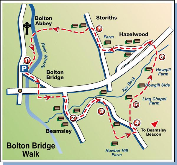
We landed one, though - reaping the reward for setting off early. There are eight free parking spaces near Bolton Bridge, at the end of Beamsley Lane. When we arrived there, two remained. Soon there was one, and that was filled before we'd got our boots on.
We set off walking down the lane to pass beneath the busy A59 and then accompany it for a while before crossing the end of the drive of Beamsley Hall and rejoining Beamsley Lane to stroll on through the attractive hamlet of Beamsley.
Here we found that there was some limited parking. And there were other, minor roadside spaces along Langbar Road as it curved and climbed up the hill before we left it and followed fields paths for a while before returning to it near Howber Hill Farm, where there was another fairly substantial roadside parking space.
So even if we hadn't managed to slot into to one of the eight spaces at the intended start of our walk, we'd have been OK for one on the early stages of the route.
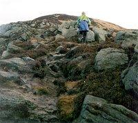
So much for parking. Now for the walking. From the point mentioned in the last paragraph we had a detour to make, up Beamsley Beacon, before returning to the road and heading for the valley bottom. And a splendid detour it was too, climbing steeply to the rocky ridge leading to the Beacon, which is around 1,000 feet above Beamsley village.
The views from the top, as we stood there in sunshine and a cool, stiff breeze, were impressive. Pendle Hill peeped out from behind the wind turbines of Chelker reservoir. Almscliff Crag showed itself beyond Timble. Curlews called and buzzards circled.
And below us, across the valley, were the houses of Hazlewood - which was where we were headed.
We retraced our steps to the road, passing the only other walker we were to encounter until almost the end of this outing, and struck off on a descending moorland path north-eastward, picking our way through various boggy bits before we arrived at the track leading past Ling Chapel Farm. It was easy walking now, strolling along this track with the steeply-rising ground of Beamsley Moor on our right and the valley containing Kex Beck on our left.
We crossed the wooded Howgill Sike and passed the farm Howgill Side and before long, sticking with track between fields of sheep and lambs, we passed Howgill Farm, which looks out over dew ponds and a lovely valley.
From there we followed a wallside down to the pretty, babbling Kex Beck fringed with clusters of primroses. What a peaceful, timeless spot this is. It was even possible to ignore the noise from the busy A59 which was with us for most of the walk.
Crossing the sturdy timber footbridge we climbed the walled track up to the road, waited until there was a gap in the traffic, and dashed across to join the quiet lane winding its way into Hazlewood. "Free Range Eggs" said a sign in the window of one of the houses we passed. Hens pecked nearby. We knocked, but there was no-one in.
Disappointed, we continued along the lane through Hazlewood. From there the lane took us steeply down one side and up the other of what was, many millennia ago, a channel scoured by overflow water from the Wharfedale glacier as it melted fast.
At the farm on the other side the cattle, yet to be let loose into the fields for the summer (this was Easter), stuck out their heads from their winter barn and munched hay.
Storiths, the twin village to Hazlewood, was a busier place. There were plenty of cars in the car park opposite the Buffers Cafe, in a farm house built in the early 1600s by Christopher Petty, father of William and Sylvester Petty (later Petyt) who both went on to have successful careers as lawyers.
We left Storiths and followed the paved, walled footpath that took us to the riverbank above the Wharfe. Here was where the Easter Sunday crowds were just starting to arrive. We joined them briefly, taking the path down to the footbridge to cross the river, walk downstream on the soft, grassy path and return to the car.
We'd barely got our boots off before someone had pulled up in the road nearby and was waiting for the spot we were about to vacate. In this part of the world it's best to be an early bird if you want to catch the free parking place.
Step by Step
- From parking place by Bolton Bridge follow Beamsley Lane sign down road to cross river then immediately go right with footpath sign on to riverbank, passing under A59 and then turning left to accompany road to Beamsley Lane. Turn right here and walk on into Beamsley.
- Go left on Langbar Road. Ignore first signposted footpath on right to Currer Hall. Instead continue to a point where road swings left and climbs steeply. At this point, grassy footpaths go ahead (right-ish) across broad grass verge, with young trees staked alongside. Follow right-hand of these paths at fork to arrive at cattle grid.
- Take stile on right into field by gate and walk up field with wall on left, going over stiles to pass behind farm and continue up open hillside and eventually arrive at wall stile into access track of Howber Hill Farm. Turn left and walk on to meet road. Cross road and follow climbing track which swings right with wall then goes left to head for top of Beamsley Beacon. Return by same route to road.
- Walk down road briefly, looking for footpath sign pointing right. Follow sloping path down moor to eventually meet track leading past Ling Chapel Farm. Go right on this track to pass through gate to right of farm.
- Keep on along this track, crossing Howgill Sike and passing Howgill Side (farm) to soon also pass Howgill Farm. Just beyond here, where wide track rises ahead in small copse of mature trees, fork left off it to follow wallside on left down to Kex Beck and footbridge.
- Cross footbridge, climb up walled track beyond to main road, cross with care and follow lane opposite to pass a couple of houses. At post box and ruined house on right, take lane to right through Hazlewood. Continue on this down dip and up other side to farm at T-junction. Turn right and walk on to Storiths.
- After visit to Buffers Cafe, walk back into hamlet and take descending lane just by roadside parking area below Storiths Cragg. Pass a fine pair of old semi-detached houses on right and then follow Bolton Abbey signpost right to go to left of farmhouse and swing left with track and go through gate stile into walled, narrow footpath which arrives at path overlooking River Wharfe. Go right, then left, to descend to footbridge across river by Bolton Abbey and follow riverbank downstream to return to start.
Fact File
- Set-off point: Bolton Bridge.
- Time for 7-mile walk: two-and-a-half hours.
- Going: easy apart from a pull up Beamsley Beacon.
- Map: OS Outdoors Leisure 2 - Yorkshire Dales Southern and Western.
- Parking: free near Bolton Bridge or at roadside in Beamsley or at various point along Langbar Road (including near Howber Hill Farm).
- Public transport: Sunday and Bank Holiday summer Dalesbus 800 and 805 from Leeds, Guiseley and Ilkley to Bolton Abbey. 806 on Sundays July 2 and September 3 from Bradford Interchange (9.45am) and various other pick-up points. Check www.dalesbus.org for full details of these and other services. Or travel by train from Embsay to Bolton Abbey Station, cross busy road and walk down old road to Devonshire Arms and start walk from there.
- Refreshments: at Bolton Abbey or cafe at Bolton Bridge.
- Toilets: at Bolton Abbey car park.


Comments: Our rules
We want our comments to be a lively and valuable part of our community - a place where readers can debate and engage with the most important local issues. The ability to comment on our stories is a privilege, not a right, however, and that privilege may be withdrawn if it is abused or misused.
Please report any comments that break our rules.
Read the rules here