
Silsden is a village which, at the time of writing, was fearful for its future. Bradford Council's Unitary Development Plan had it earmarked for a substantial amount of house building which, those who lived there feared, would change its nature for the worse.
So it was off to Silsden that I took myself, to take a walk through it and in the fields around it and enjoy it as it was, before the builders moved in and start nibbling away at the edges of it.
For added interest I took as my guide a little book called Walking in Airedale, compiled 25 years ago by the Bradford group of the Ramblers' Association. How had Silsden changed already, I wondered, compared to when it was written. To which the answer must be, as far as this walk is concerned: not a lot.
The most obvious change came as I left the village, walking up to the top of Hillcrest Avenue and discovering a new housing estate there. The shape of things to come? But beyond that, the fields of wild flowers were much as they've always been and the view to the east, of the fields rising to Horn Crag, was open and uninterrupted by any sort of development.
But who could blame the people of Silsden for wanting things to stay as they are, when as they are is as lovely as this? My route took me through some glorious wildflower meadows and across a pretty beck and the on a high road with superb views across the Aire Valley.
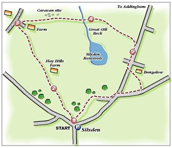
Only twice did I find that I had to divert from the route set down in 1972 by the Bradford ramblers — a route which, thanks to the Bradford Countryside Service, was well way-marked along much of its length.
At one point there seemed no way I could pass in front of a farm, as instructed. Instead, after consulting my map, I headed off down a lane in search of another right of way — which I found, only to spy a large, brown bull at the far end of the field. So it was back to the map, where I discovered an easier and safer route closer to the original. There were only sheep and lambs in this field. What a relief!
The second diversion occurred after a fallen tree blocked the path down to the pretty Great Gill Beck, and I had to head up-stream to find another way across, getting my boots washed in the process.
On the return route, passing through fields above Silsden Reservoir, I found myself being rounded up by a farm dog which had only minutes earlier been doing the same job with a flock of sheep and lambs. Wonderful working dogs, Border Collies, but single-minded to the point of barminess, I'm afraid!
Step by Step
- Leave pay-and-display car park in Silsden and walk right up main street. By bus shelter, cross road and go up street ahead, passing public toilets and then pub on left to head into Bridge Street. Cross over and go up Hillcrest Avenue, passing Co-op on right. At top of Hillcrest Avenue continue into start of track, but immediately go through stile by gate on left. Follow hedge on right, then at field corner go left up field to stile on right at top.
- Follow waymark left to another stile then continue with hedge on left to Hayhills Farm. Just before farm, go left over stile into lane. Turn right to reach farm road. Cross it and go over stile into field. Walk diagonally across field. Go through gate and keep trees and bubbling stream on right, then go right (again following way-mark) over clapper bridge. Continue with hedge on left to stile into garden of house. Walk up past house and along its access road to pass farm on right and reach road.
- Turn right here, walking past houses on left and soon taking access road to caravan site to right. Immediately before farm building, go right over two stiles in field, then turn left and walk down field to gate stile into caravan site. Go diagonally across caravan site and in same direction across next field, with old chimney on skyline ahead. At next stile, head down field with hedge on right. Meeting path at bottom, go left and descend to Foster Gill Beck. Cross, then turn right to re-cross it near confluence with Great Gill Beck and cross footbridge.
- After crossing, head up left away from stream as soon as you can (given that a tree-line is a bit of an obstruction) to reach a fence. Turn right. Walk along fence, or wall, or fence, over three stiles into path leading towards house. Turn left and go over stiles to road. Turn right and walk down pavement, with views of Silsden Reservoir and Aire Valley to left.
- Ignore first footpath sign to left, on far side of road. Instead, look for footpath sign left at top of steep hill, just past access lane to bungalow. Cross road with care. Go over stile and walk up wallside to another stile on right. Walk along with wall on right, fairly soon going over stile in it and continuing with wall and then fence and then wall again on left. Go over stile in this wall, turn right, and then soon head quarter left across field to stile just to left of house. Turn right down lane to junction and cross over to go down North Street back to centre of Silsden.
Fact File
- Time for about four miles from centre of Silsden: two hours (if the walk is from Steeton and Silsden station, add a couple of miles and an hour).
- Going: easy.
- Map: OS Pathfinder 671, Keighley & Ilkley.
- Getting there: drive up Aire Valley road from Keighley, turning left at roundabout to Silsden. Or catch train to Steeton and Silsden station from Bradford or Shipley.
- Parking: pay-and-display on right at top end of Silsden (40p for two-and-a-half hours, or £1 for longer.
- Refreshments (and toilets): in Silsden.


Comments: Our rules
We want our comments to be a lively and valuable part of our community - a place where readers can debate and engage with the most important local issues. The ability to comment on our stories is a privilege, not a right, however, and that privilege may be withdrawn if it is abused or misused.
Please report any comments that break our rules.
Read the rules hereComments are closed on this article