
It’s strange to walk beside the calm surface of a reservoir, rippled only by swimming ducks, geese and the occasional rising trout, and remind yourself that beneath those 1,725 million gallons of cloud-reflecting water are the remains of a church, cottages, a school, country lanes and garden walls.
The village of West End isn’t a mythical place. It existed until the start of the 1960s when it was evacuated, its buildings largely demolished and the trees around it felled. That work was done prior to the completion in 1966 of the dam which created Thruscross Reservoir, the fourth and highest of Yorkshire Water’s Washburn Valley reservoirs (Fewston, Swinsty and Lindley Wood are the others, in descending order).
West End re-emerges from time to time – not rising from the water like some spectre, but when there’s a drought and the water level drops dramatically. That happened in the summers of 1989 and 1990.
That was the last time I walked along the shoreline of this reservoir, going on to join the hundreds of people who had turned out to savour the rather spooky experience of strolling among the piles of stones which had once been people’s homes.
There was no drought on our latest visit, though. As we all know well enough, last winter was extremely wet and during the first week in April, when we did this walk, there was still plenty of rain falling from time to time. In fact the forecast for this midweek day had been for heavy showers, but the broken cloud and large patches of blue sky tempted us to risk getting a soaking on our way round.
We set off from the Yorkshire Water car park off Reservoir Road (a well-made one with display boards, picnic tables and benches, though no toilets) and headed off through the woods on a well-made path. There have been a lot of improvements to access since we were here last. It’s now very easy walking along the western shore of the reservoir.
The woodland has been thinned to let more light through, many of the felled trees being left to lie and rot to provide food and cover for wildlife of various types. There was plenty of birdsong as we strolled along, plenty of flashes of colour as chaffinches darted between the trees. We interrupted a pair of tiny warblers busy building their nest which dangled precariously from dry reeds. A huge heron took off as we approached and flapped silently across the water.
We crossed the truncated road that once led to West End, its crumbling tarmac disappearing into the water, and continued alongside the western spur of the reservoir to the point where Capelshaw Beck joins it. There we met the road.
We could have turned sharp right at the far side of the bridge and rejoined the reservoir via a path through the trees. But we had other plans, intending to follow Yorkshire Water’s recommended, permissive route.
Plodding up the hill on the tarmac, we turned at the top into the access road of Whitmoor Farm and within 250 yards turned off it to follow fields paths which were to lead us to the northernmost tip of Thruscross. The views were memorable, the moors and fells to the north and the reservoir chain stretching down the valley in the opposite direction. So was the encounter, immediately after climbing over a wall stile, with a ewe and her tiny new lambs, one of them still wobbly on its legs.
We left them to their bonding and feeding and continued along the top of the tree-line to arrive at a rustic seat placed there in the names of Victor and Annie Verity, who both died in 1984. What a splendid spot had been chosen for this memorial to them, looking down on the embryonic River Washburn and the uplands that are its catchment area.
After soaking in the sights we picked our way down the steep, stepped hillside to a sturdy if not particularly attractive footbridge. From there we had a choice. We could plunge sharp right into dark and gloomy conifer woodland and follow a path downstream to rejoin the reservoir on its eastern shore. Or we could strike up more steep steps towards Rondell’s Allotment. With the sun shining pleasantly and no showers in sight, no prizes for guessing which we chose.
It was a bit of a slog up the hill but well worth it on the top as we strolled along the wide, grassy track, following a line of well-spaced waymark posts, to eventually swing round towards the south and return to the reservoir.
This stretch of footpath wasn’t anything like as well-made as on the far shore. Easily passable though, even on the several muddy stretches. With the dam carrying Reservoir Road now in our distant sights, we strode along happily, thoroughly enjoying the outing. It was on the final, paved stretch that we passed the only two other walkers we met during this circuit.
There must have been more in the area. When we’d parked up, there was just our car. On our return there were seven. It might get crowded up here at the weekends, but on weekdays you can almost imagine you have this beautiful part of the world to yourself.
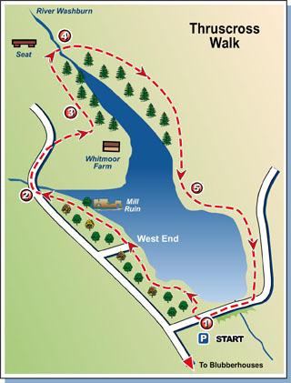
The route
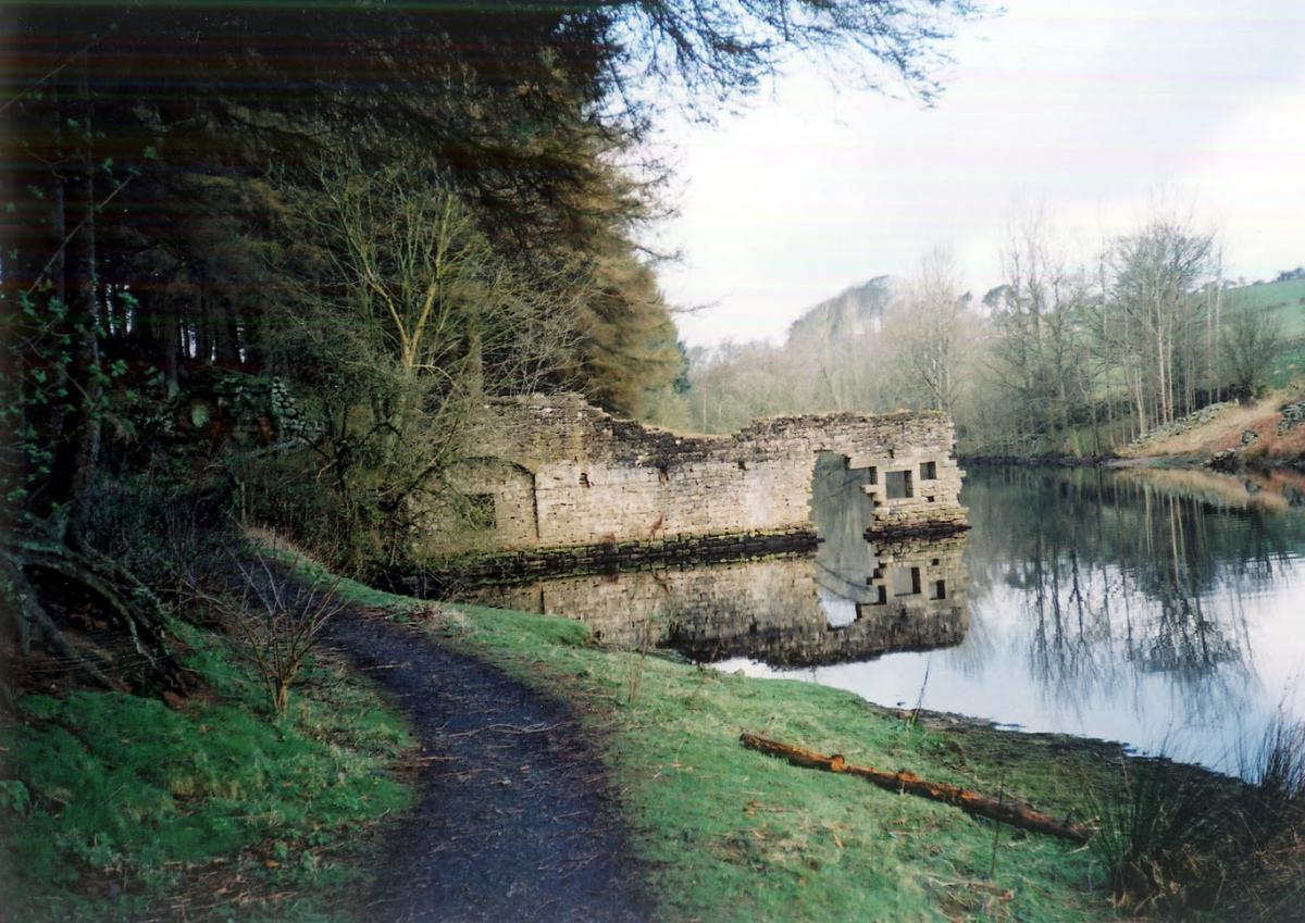
1 From main entrance to Yorkshire Water car park, cross Reservoir Road and go through stile into wood. Follow good, made path to water’s edge and head north, detouring away from reservoir shore briefly a couple of times to cross footbridges, close to where old road disappears into the water, below, and eventually walk alongside western fork of reservoir, past ruin of old mill, to arrive at road.
2 Turn right in road, cross bridge and walk up hill beyond. Pass private drive to house on right and at top of hill go right into access track for Whitmoor Farm. When this road meets a gate with footpath signpost, go left and walk on with wall on right to stile in corner. Climb this stile and go left over immediately adjoining one.
3 Continue with wall on right to a gate with stile next to it. Don’t go over this, but instead turn left following direction indicated by signpost, half-left across field on clear track, soon walking parallel with fence and tree line on right to arrive at ladder stile. Over this, walk ahead to seat then go down steep steps to footbridge.
4 Across bridge, walk up steps ahead towards rocky outcrops then continue on to open moor Roundell’s Allotment. Follow posts across this to gate and stile in facing fence. Walk up to next post with rising ground beyond. Don’t be tempted to turn right here and head for another post down hill. Instead continue in same line over brow of hill. Keep following posts as path swings south and eventually leads to stile and path descending to reservoir side.
5 At water’s edge, turn left and follow clear path round shore to arrive at road. Follow road across embankment and back to start..
Factfile
Start: Thruscross car park in Reservoir Road.
Time for 4½-mile walk: two hours-plus.
Going: moderate with a couple of steep uphill pulls.
Map: OS Explorer 27, Lower Wharfedale & Washburn Valley.
Toilets: none along route.
Refreshments: ditto.
Getting there: from Otley, take the Blubberhouses road to junction with A59. Cross straight over into narrow road signed to West End. Follow this looking for Reservoir Road on right. Turn into this for car park (free).


Comments: Our rules
We want our comments to be a lively and valuable part of our community - a place where readers can debate and engage with the most important local issues. The ability to comment on our stories is a privilege, not a right, however, and that privilege may be withdrawn if it is abused or misused.
Please report any comments that break our rules.
Read the rules here