

There are footpaths galore around Haworth. Just when you think you might have walked them all, you can chance upon one you never knew was there. Or you can find yourself trekking along another that's obviously well trodden - but not, previously, by you.
There were some surprises on this outing, which began in the heart of Haworth, at the council-run car park tucked away off the main road near the Parsonage (beware the non-council one on the left-hand side of the road as you drive up through the village, because you could possibly get clamped and have to pay a large penalty to secure the release of your vehicle, which is one surprise you can do without).
We headed, first of all, up the steps from the car park towards the Parsonage, turning down toward the church but then diverting before it to walk across the church yard past the congestion of headstones and monuments.
Soon we were on the path between railings, which led us into a continuation of this enclosed path between allotments where chickens clucked.
At a junction of paths we didn't follow the one I was familiar with, that climbs to the right. Instead we went straight across on a narrower path that continued between walls and picked its way around the perimeter of Snowden Farm before crossing a stile into a field.
Signs indicated that the route lay up the field briefly and then, after another stile, passed between the farm buildings where washing blew in the cool Saturday breeze, before climbing to Dimples Lane.
With not a hint from the map as to where we went from here, and no signs to guide us, we vamped it. We crossed the road and followed the broad, green double track up the moor before meeting a narrow crossing path. We followed this as it snaked up and down through the heather to meet another path.
To our left was an attractive tarn I'd never come across before, despite spending lots of time up here with our grandson doing the Penistone Country Park "Numbers Walk" dreamed up by Bradford Council's Countryside Service and described in one of their leaflets.
We skirted past the tarn, climbed the other side, and found ourselves in familiar territory. Ahead was the cricket pavilion near the hilltop car park and beyond it the rough access track leading down to the road that runs between Lower Laithe Reservoir and Oxenhope.
Soon we were on the broad track leading to Drop Farm with its tearoom, where a sign informed passing trade that it was closed. There was a choice of routes from here. A left turn would have sent us in the direction of Hebden Bridge. We, though, wanted the route signed to the Bronte Falls and Top Withens.
There was perfect silence up here as we kept on with the wall. Wide-open views across Leeshaw Reservoir were to our left. Past clusters of hardy, grazing sheep, a signpost eventually showed the way northeastwards, through the heather.
The path was narrow but clear and obviously well walked over the centuries. Despite a couple of rainless weeks it was boggy in places (so think on, and wear decent boots!), but someone had helpfully laid flat stones across the worst bits.
Before long we were at a broad track again, leading up the moor to a distant farm named on the map as Harbour Lodge. You couldn't be much further from the sea, so we must assume that the "Harbour" refers to a safe haven.
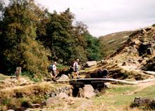
In a dip in the track just before this cluster of buildings a sign to the Bronte Falls and Top Withens pointed left, down the hill to a rickety footbridge. At the other side we again had a choice. We took the Bronte Falls path that more or less followed the stream until it began to fall steeply, shuttering down to meet the beck in the valley bottom.
We proceeded down the eroded path with great caution, anxious not to join in the shuttering.
The Bronte Falls always seem a little disappointing to me. When I've visited there's never been much water passing down them and anyway the view of the biggest drop is obscured by a large silver birch tree.
Far more romantic is the Bronte Bridge, on which a young couple were sitting, side by side and with their heads together, eating lunch and perhaps dreaming of Cathy and Heathcliff.
These were the first people we'd seen since we left Penistone Country Park. We were to see a lot more, though, as we made our homeward trip along the well-trodden Bronte Way which most visitors to the falls follow from the village and headed back to the car along the flagged path through the field and behind the houses to the Parsonage.
The views throughout had been a delight. Small wonder this area is so popular. Even without the Bronte connection it has a huge amount of appeal.
Step by Step
- From car park, go up steps towards Parsonage, turn left to church and go right just before it to cross church yard and join path between railings. On leaving churchyard, continue ahead along enclosed path. At junction, keep ahead on narrow enclose path signed "Bronte Way and Oxenhope". Follow this to stile into field just to left of Snowden Farm. Walk up fieldside briefly then go right over stile and between farm buildings to turn left and walk up access road to Dimples Lane.
- Cross road, follow green track leftwards up moor, and at narrow crossing path go right. Follow this as it winds through heather to climb and meet another path. Go left towards tarn, turning right before water to walk in front of it and climb up other side. Head now for wooden cricket pavilion and walk past Penistone Hill car park on right and at fork follow left-most of two access roads to main road. Go left down road briefly, then right following Bronte Falls and Top Withins sign towards Drop Farm Tearooms.
- Immediately past Drop Farm, keep on with wall on left until a sign points half right across moor. Follow this to meet a broad, crossing track. Turn left and head for Habour Lodge.
- In dip just below lodge, go right with signpost, Cross footbridge (with care). At signpost beyond, follow Bronte Falls direction, staying close to stream. Proceed with caution as path steepens dramatically to descend to Bronte Bridge.
- From bridge, don't cross beck but instead turn right and walk downstream, climbing steps initially and then walking above valley along Bronte Way, passing a ruined farm and then a working one to return to road.
- Cross and follow Cemetery Road back towards Haworth, going right soon after it joins Stanbury road at a fork through a gate stile into field and along causeway back to Parsonage.
Fact File
- Start: Centre of Haworth, near Parsonage
- Time for six-mile walk: 2 hours
- Going: Moderate, with one steep downhill scramble
- MAP: OS Outdoors Leisure 21, South Pennines
- Getting there: By train from Keighley, walking up through village to start, or by 696 bus from Bradford, 500 from Keighley
- Parking: Council car park
- Toilets: At entrance to council car park in Haworth
- Refreshments: In Haworth.


Comments: Our rules
We want our comments to be a lively and valuable part of our community - a place where readers can debate and engage with the most important local issues. The ability to comment on our stories is a privilege, not a right, however, and that privilege may be withdrawn if it is abused or misused.
Please report any comments that break our rules.
Read the rules here