

Sustrans, which is already responsible for creating 10,000 miles of the National Cycle Network and is adding to that total all the time, deserves a big vote of thanks from walkers as well.
Thanks to the charity's efforts over the past few years, they and horse riders are able to share routes created primarily with cyclists in mind, passing across open countryside and linking urban centres.
Much of Sustrans's work involves disused railway lines. It can't be easy always to make the connection, when embankments have been bulldozed, cuttings have been filled in and housing or factories built on the land.
How much easier it would have been if, nearly half a century ago when Beeching was wielding his axe over hundreds of branch lines, someone in government had had the foresight to see the potential in the routes freed up and begun there and then a programme of paving over them and turning them into a network free of motorised traffic.
If those closures were to happen now, when the big buzz is about reducing carbon footprints, that railway network might have been seen as the precious resources it undoubtedly was. A lot of it has gone, but Sustrans is doing fine work with what remains to increase awareness of sustainable transport and encourage more people to pedal and walk rather than climb into a car.
Nearly half of the population live within a mile of the National Cycle Network and a growing number are making use of stretches of it: to cycle to school or work, to walk to the shops in the nearby town, or simply to get out and enjoy the fresh air, exercise and fine countryside that many stretches of this network pass through.
There has been a lot going on within easy reach of Bradford. The Cullingworth stretch of the Great Northern Trail has recently had the Queensbury section added to it. The Spen Valley Greenway between Oakenshaw and Dewsbury, mostly on disused railway, is now linked up with the Calder Valley and Birkby Bradley Greenways between Dewsbury and Huddersfield, passing through Mirfield.
Over at Wetherby, the stretch of disused railway between the town centre and Spofforth has for several years been enjoyed by walkers, riders and cyclists. And to that has now been added a new stretch of just over two miles between Wetherby and Thorp Arch trading estate and retail park.
Those who work and shop there now have access to a virtually traffic-free route (there are still two roads to cross). The link was opened on June 21 and a month later we set out to sample its delights.
First task, though, was finding the start of it, which I'd been told was in Freemans Way. We parked in the main car park by the river and walked up into the town and along the main street between shops and pubs before turning to pass Morrisons and Marks & Spencer's and, soon, Wetherby High School.
When Hallfield Lane swung sharp left, we swung with it and continued past the playing fields and primary school until we arrived at Freemans Way on the right.
It turned out to be a residential road with the busy A1(M) at the far end of it. And according to a sign, that was where our walk was to begin: at an underpass taking us beneath the racing traffic.
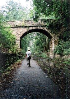
This stretch has clearly been in existence for some time. The surface is paved, the verges are full of flowers, berries and mature bushes and trees. We were close enough to Wetherby racecourse to have had a good view of the action had it been a race day. A couple of cyclists passed us. We encountered several dog walkers. And there was one man heading in the direction of Wetherby with his shopping bag.
In the fields either side of the track rabbits grazed. Goldfinches flocked in the trees. All was pleasant and quiet until the track turned and drew closer to Walton Road with its traffic noise.
We crossed the road and rejoined the track on the other side back into peace and quiet: a rawer stretch now, recently created and with the undergrowth still to mellow the verges. The route passed through a low, shallow cutting before emerging again into open countryside and meeting the road opposite Thorp Arch prison.
Another new stretch followed, winding its way through the trees and past factories and warehouses to end at the junction of roads on the trading estate. From here, with no shopping to do, we tried and failed to find a footpath that would take us down to the river, allow us to cross it and follow the Ebor Way upstream.
So we retraced our steps back to the prison and followed the pavement into the attractive Thorp Arch village, crossing the wide Wharfe into equally attractive Boston Spa which was busy with its own shoppers.
From there, a bus took us back to Wetherby in a matter of minutes.
Step by Step
- From main car park by river, walk up ramp to road, turn right and walk on between pubs and shops to turn right into Horsefair (just past pub on corner). Walk down between M&S on right and Morrisons car park on left, following Hallfield Lane past Wetherby High School. Turn left with Hallfield Lane and walk on past primary school and nursery, eventually turning right into Freemans Way.
- Walk along Freemans Way towards A1(M), following footpath sign down subway and emerging at far side on to new cycleway/bridleway/footpath. Follow this ahead, sticking with it as it rises to cross another bridleway then continues at far side to eventually meet Walton Road.
- Cross Walton Road and keep on along cycleway at far side to eventually arrive at road near Thorp Arch prison. Cross this, doglegging right/left, and continue along new stretch of cycleway as it winds through trees to emerge at corner of trading estate.
- Now either go and do some shopping, or turn around and return along path to road. Cross, turn left and walk along pavement to junction. Go right here, and walk on to top of Thorp Arch village, passing school. Turn left and walk down through Thorp Arch to cross river and walk up to main road in Boston Spa. Turn right here and walk on towards church, from where two buses run back to Wetherby - one on the church side, which goes via Thorp Arch, the other from across the road taking a more direct route.
Fact File
- Start: Centre of Wetherby, either the riverside car park or bus stop in centre of town
- Time for four-mile walk plus bus ride: A couple of hours
- Going: Easy
- Map: OS Explorer 289 Leeds, Harrogate, Wetherby & Pontefract
- Toilets: In centre of Wetherby
- Refreshments: Pubs and cafes in Wetherby, Thorp Arch and Boston Spa


Comments: Our rules
We want our comments to be a lively and valuable part of our community - a place where readers can debate and engage with the most important local issues. The ability to comment on our stories is a privilege, not a right, however, and that privilege may be withdrawn if it is abused or misused.
Please report any comments that break our rules.
Read the rules here